NavList:
A Community Devoted to the Preservation and Practice of Celestial Navigation and Other Methods of Traditional Wayfinding
From: Robin Stuart
Date: 2013 Aug 31, 08:16 -0700
It was an ideal day for noon sights with the only obstacle being the occasional 50 metre yacht sailing past and blocking our view of the sea horizon. Our presence attracted quite a few curious onlookers. Frank patiently fielded their questions, explained the fundamentals of CelNav and showed some what the noon Sun looks like through a sextant.
Below are my observations. The sights are all Sun LL and were taken on 25 August, 2013 from 41d26’56.7”N 71d23’57.7”W. In calculating the intercepts I took the height of the eye to be 9m giving a combined correction for refraction, semi-diameter and dip of +10.1’. LAN occurred at 12h47m34s EDT around which time the Equation of Time was -1m58s. The sextant measurements along with the intercepts are
EDT Hs Intercept
12h33m35s 58d47.6' 1.7 T
12h37m37s 58d50.6' 0.2 T
12h40m51s 58d53.4' 0.5 T
12h42m40s 58d54.0' 0.2 T
12h45m46s 58d54.9' 0.1 T
12h47m47s 58d55.6' 0.7 T
12h49m36s 58d55.6' 0.9 T
12h51m15s 58d54.6' 0.4 T
12h53m19s 58d53.2' 0.0 T
12h56m56s 58d51.0' 0.4 T
12h58m45s 58d49.5' 0.6 T
13h02m53s 58d44.2' 0.5 T
13h08m19s 58d35.2' 0.7 T
13h09m48s 58d32.0' 0.5 T
Clearly from the intercept the first observation is a bit of an outlier.
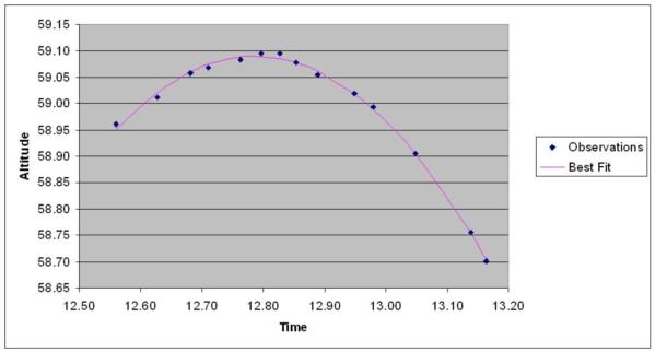
The sights are plotted in the attached image with the least squares fit to a parabola. It is also possible to fit to the usual altitude formula but in this case it doesn’t make much difference in the accuracy of the fix. It might however make a significant difference when the attitude of the Sun is much higher and a simple parabola is not a good fit.
Working from the single maximum altitude alone yields a latitude of 41d26.2’ in error by 0.7nm. Using the time and maximum altitude obtained from the fit gives a position of 41d26.5’N 71d17.9’W which is an error of 0.4nm in latitude and 4.5nm in longitude. If the first observation in the series is excluded the longitude from the fit becomes 71d23.3’W which has an error of just 0.5nm! Fluke?
Robin Stuart
----------------------------------------------------------------
NavList message boards and member settings: www.fer3.com/NavList
Members may optionally receive posts by email.
To cancel email delivery, send a message to NoMail[at]fer3.com
----------------------------------------------------------------


