NavList:
A Community Devoted to the Preservation and Practice of Celestial Navigation and Other Methods of Traditional Wayfinding
From: Frank Reed
Date: 2010 Apr 10, 23:52 -0700
I've compiled all the longitudes and other navigational observations from the American vessel Reaper, Isaac Hinckley commanding, which sailed in 1809-1810 from Boston to Mocha and eventually Calcutta and the same for the British Royal Navy vessel Bounty, William Bligh commanding, which sailed from Portsmouth to Cape Horn and eventually Tahiti in 1788-89. The Reaper returned home to Boston. The Bounty infamously did not return to Britain.
The Bounty carried an early chronometer in an era when the word chronometer had not yet appeared, except in jest, and these instruments were known as "Time Keepers". Bligh checked its error and at least once its rate by taking lunar observations on a fairly regular basis for a few days around First and Last Quarter in most months. He kept three longitudes usually: the DR longitude which is nearly always recorded, the longitude by T.K., and the longitude by "Lun & T.K." which is updated to reflect the estimated error in the Time Keeper longitude based on the lunar observations every two to four weeks. The longitudes by lunars are recorded and analyzed in the main pages of the logbook when they are taken. We have the resulting longitudes from each individual observation but not the measured distances themselves.
The Reaper, twenty years later, carried no chronometer, and this seems to have been typical of American merchant vessels at that time. American ocean-going vessels typically carried chronometers starting after about 1835 (very roughly, of course --it was a gradual transition). Since there was no chronometer, the lunars taken aboard the Reaper were used as a check on the dead reckoning. Like Bligh, and apparently in keeping with typical practice, Hinckley checked the dead reckoning by shooting lunars for a few days around First and Last Quarter. He kept two longitudes frequently: the DR longitude which is always recorded when the vessel is out of sight of land, and a second longitude "by Lunars" which moves in lock-step with the DR longitude and is, in fact, a separate DR longitude using a new starting longitude derived from the lunars at a few points in the voyage. The logbook of the Reaper includes the details of the calculations and the measured distances and altitudes for the majority of the lunar observations, all written down neatly on pages in the back.
The lunar navigation aboard these two vessels, two decades apart, one a prime example of British Royal Navy practice and the other a fine example of American commercial maritime practice, shows many common features and some interesting differences. As I've noted above, the general usage is to shoot lunars for a few days around First and Last Quarter so lunars taken using the Sun as the other body are the principal sights considered valuable for navigation, not by law or rule by reasonable common navigational practice. But both Bligh and Hinckley do shoot star lunars. Hinckley shot a couple of star lunars, less than 10% of his lunars. Bligh, by contrast, shoots stars fairly often, about 25% of the total. But it's not for the reason that you might expect. Twice he shoots stars because he must do so at times Sun lunars were simply not available, but for the most part he takes lunars with stars on the same day that he shoots lunars using the Sun because he is trying to get objects both east and west of the Moon in order to average out systematic errors in his sextants. This was often recommended in this period. Like most navigators though, and like Hinckley twenty years later, Bligh much prefers Moon-Sun lunars and twice when the weather has been cloudy he specifically notes in his logbook that he is disappointed that the weather is bad since "the Moon is in distance with the Sun."
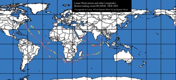
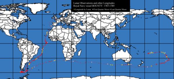
You can get a general sense of the frequency and significance of lunars to these navigators by looking at the maps I've prepared of the two voyages which are attached to this post. They're a little crude, but even so they tell the story pretty well I think. I've used the best available latitude on each date, which is probably accurate to five miles and frequently better. Then the various longitudes are plotted. I haven't provided detailed keys for the DR and other running longitudes, but you can see that there is some spread in the longitudes if you look closely. The critical longitudes mapped here are the longitudes by lunars. They're indicated with yellow boxes in the two charts. Notice in both charts that these tend to come in small groups. These are the periods of time when Bligh or Hinckley are shooting lunars for several days in a row. I've also tried to mark the dates when the Moon is at First Quarter and Last Quarter (gray diamonds and gray stars respectively).
Notice in the Reaper voyage that lone lunar in the South Atlantic near 30 South and 2 West. There's no nearby marker for a First Quarter or Last Quarter phase, and, sure enough, that was an Antares lunar. It's interesting that he did not use this lunar observation at all. He simply recorded it. Coincidentally, Bligh on the Bounty also shot some Antares lunars when he was approaching Tasmania. You can see that lone yellow square on the Bounty map. In his case, the Moon was very nearly full so he shot both Near and Far limbs and averaged the sights.
By the way, since the outbound and return trip of the Reaper's voyage are plotted on the same map, it gets confusing. I've tried to distinguish the return track by plotting the DR longitudes in a slightly orange tint on that track. The outbound track from Boston is north of the return track in the North Atlantic, south of it in most of the South Atlantic, then swings north to Arabia and after that runs just south of the equator until turning north to Calcutta. The return track is simpler, running nearly straight south from Calcutta for over 2000 miles into the southern Indian Ocean, then around southern Africa and almost straight across the Atlantic back to Boston. The multiple tracks visible between Ceylon and Sumatra show genuine uncertainty over the longitude at that time on the outbound voyage. Hinckley's lunars proved correct but he didn't really believe them until he sighted Sumatra one morning.
In the logbook of the Bounty, in addition to the analyses of the lunars to check the Time Keeper, there are several other interesting celestial navigation details:
1) Very early in the voyage, Bligh calculates the correction of the Sun's meridian altitude for the Noon latitude to the second of arc, noting the dip is 3' 18" and the Sun's SD is 16' 19". That's a bit of over-kill, of course, and later in the voyage he uses the common +12' correction used back then that combined dip (-4' for typical vessel), SD (+16'), and ignored refraction as negligible.
2) Bligh finds the latitude by double altitudes of the Sun several times and notes this in his logbook.
3) On several occasions he notes that he got the altitude of the Sun exactly at noon as determined by the Time Keeper. That strikes me as rather unusual, especially for this period when chronometers were expected to be close but not perfect.
4) There's at least one latitude observation by meridian altitude of the Moon which seems to have been more common back in the late 18th and early 19th centuries than we would guess today.
The logbook of the Reaper is in the collection at Mystic Seaport, but it is not available online unfortunately. The logbook of the Bounty is online and can be accessed through the CORRAL site, which George pointed out and which is now listed prominently under Resources on the NavList message boards. The logbook of the Bounty is naturally an object of great interest, thanks to the mutiny, and so it's been transcribed several times. I worked through the scanned original for about 75% of the voyage, just to convince myself I had the original source information, but I've discovered that the transcription available at www.fatefulvoyage.com is nearly perfect.
-FER
----------------------------------------------------------------
NavList message boards and member settings: www.navlist.net/NavList
Members may optionally receive posts by email.
To cancel email delivery, send a message to NoMail[at]navlist.net
----------------------------------------------------------------


