NavList:
A Community Devoted to the Preservation and Practice of Celestial Navigation and Other Methods of Traditional Wayfinding
Re: Cugle - longitude at sunrise and sunset
From: Gary LaPook
Date: 2013 Apr 30, 22:32 -0700
From: Gary LaPook
Date: 2013 Apr 30, 22:32 -0700
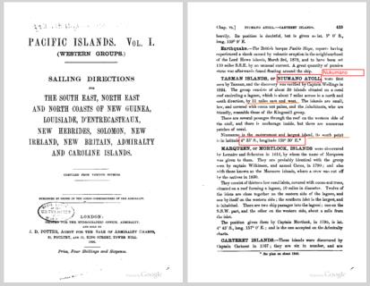
| If you wade through van Asten's published papers you realize that he comes up with the 0718Z position report based only on a precomputation, (DR ?) no solar observation needed, according to him! So just leave the sextant at home and just do the van Asten pecomputation! The reason I have spent so much time on the 0718 Z position report, which is twelve hours prior to the approach to Howland, is that van Asten then uses this supposed fix to compute the sunrise fix as the plane approached Howland. (I know, this doesn't make sense, you will just have to read his papers to figure it out for yourselves.) Van Asen apparently doesn't understand that you need two LOPs to determine a fix and he claims that Noonan determined those fix coordinates by use of only a sunset observation (in fact, he leaves out the necessary OBSERVATION and claims it can be "precomputed", no observation necessary). So where does he get the other LOP? . How did Noonan come up with those coordinates? I'll give you a hint, he didn't read it off of a GPS display. If you say he did it with celestial navigation then tell what two objects were available in the sky at the times and at the coordinates that we are considering? It takes two objects to determine a fix. Well.....there was only one object, the sun, and at the 0718 Z time and position the sun was too low, less than 6°, for Noonan to take an observation of it. Oh, Oh, Oh, I know, isn't there such a thing as a "running fix" that you can get by observing just one celestial object? (A little knowledge is a dangerous thing.) Well, yes, but it wouldn't work here. To get a running fix you take an observation of the object (usually the sun) wait a period of time, say one hour, and then observe the sun a second time. You then plot the two LOPs after advancing the earlier LOP based on the DR movement of the plane, to account for that movement, and where the two plotted LOPs cross is the running fix. To get an accurate fix you need the two LOPs to cross at a large angle, 90° is the ideal, but certainly the angle must be greater than 30° and even at that angle the uncertainty in the resulting fix is doubled, and it gets much worse as the angle gets less. A 0419 Z (one hour early) the azimuth of the sun (in the area of the earlier coordinates) was 308° and at 0519 Z it was 301° so the crossing angle (called the "cut" by navigators) of the resulting LOPs would have been only 7° producing an unusable running fix with an uncertainty of more than 95 SM. It would have been even worse for a running fix at 0718 Z because the crossing angle would have been only 2° producing an uncertainty of 330 SM! And after 0650 Z the sun would have been too low to shoot anyway. (van Asten just couldn't get these concepts.) (The uncertainty in a perfect celestial fix, shot from a plane, is 10 NM (11.5 SM) if the cut is the perfect 90°. When the cut is less than 90° then the uncertainty varies with the cosecant of the cut, times to perfect 11.5 SM.) So how did Noonan get the reported coordinates? He looked out the window. At 0519 Z they were over the center of Choiseul and at 0718 Z (or earlier) just to the west of Nukumano both providing good visual fixes with Noonan getting the coordinates from his chart. The coordinates that van Asten uses for Nukumano is for the farthest south east end of the atoll, see attached page from the 1890 Sailing Directions. Noonan passed near the western end of the atoll about 11 NM further west. There is no evidence that Noonan carried such books on the plane so he would have gotten the coordinates by measuring them on his chart which accounts for the slight difference between his reported coordinates and the actual coordinates that we know for the western end of the atoll. gl --- On Tue, 4/30/13, h.a.c. van Asten <hac.vanasten@gmail.com> wrote:
|


