Welcome to the NavList Message Boards.

NavList:

A Community Devoted to the Preservation and Practice of Celestial Navigation and Other Methods of Traditional Wayfinding

Compose Your Message

Message:αβγ
Message:abc
Add Images & Files
    Name or NavList Code:
    Email:
       
    Reply
    Low Altitude Sun Artificial Horizon Exercise
    From: Greg Rudzinski
    Date: 2020 Nov 29, 08:50 -0800

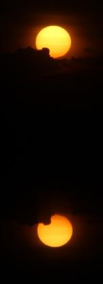
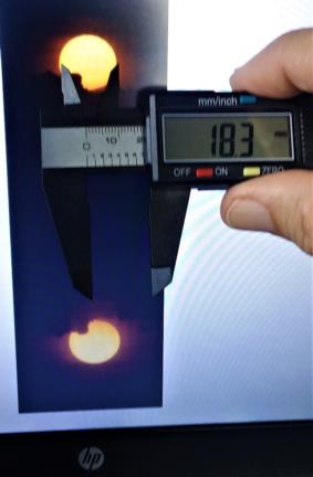
    This exercise is to show how a plastic digital caliper can accurately measure any low altitude Sun image using the horizontal diameter as the yard stick.

    Image #0759 

    UT 22:16:31    28 November 2020

    Lat. 27° 41.7' N   Lon.  80° 23.9' W  (GPS)

    Diameter of Sun 32.434'   

    What is the azimuth and intercept from GPS ?

    Greg Rudzinski

    The image is using a 135mm vintage lens on a Canon 2000D (24MP). Settings: 1/4000sec, ISO 100, f 16. Sun filtered with double polarizers.
    File:


    File:


    Reply
    Browse Files

    Drop Files

    NavList

    What is NavList?

    Get a NavList ID Code

    Name:
    (please, no nicknames or handles)
    Email:
    Do you want to receive all group messages by email?
    Yes No

    A NavList ID Code guarantees your identity in NavList posts and allows faster posting of messages.

    Retrieve a NavList ID Code

    Enter the email address associated with your NavList messages. Your NavList code will be emailed to you immediately.
    Email:

    Email Settings

    NavList ID Code:

    Custom Index

    Subject:
    Author:
    Start date: (yyyymm dd)
    End date: (yyyymm dd)

    Visit this site
    Visit this site
    Visit this site
    Visit this site
    Visit this site
    Visit this site