Welcome to the NavList Message Boards.

NavList:

A Community Devoted to the Preservation and Practice of Celestial Navigation and Other Methods of Traditional Wayfinding

Compose Your Message

Message:αβγ
Message:abc
Add Images & Files
    Name or NavList Code:
    Email:
       
    Reply
    Re: Lunar altitudes
    From: Fred Hebard
    Date: 2003 Apr 16, 14:31 -0400

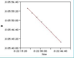
    I thought I'd post a graph of Gregory's lunar listed by George
    Huxtable, despite the injunction against attachments.  The line is a
    fit of a straight line to the data, which had an R-square of 0.9990.
    
    To fit the data on my spread sheet, which knows about hours, minutes
    and seconds, but not degrees, minutes and seconds, I subtracted 24
    degrees from the distance.  Also, since George had bragged about the
    data being so good, I assume that his data point at 22h 39m 00s 29d 43'
    50" was a typo, where the 43' should have been 45', and changed that
    point accordingly.
    
    To all us nascent lunarians, when our data on land look like these, we
    should be as ready as we can be for sea!
    
    Fred


    File:


    Reply
    Browse Files

    Drop Files

    NavList

    What is NavList?

    Get a NavList ID Code

    Name:
    (please, no nicknames or handles)
    Email:
    Do you want to receive all group messages by email?
    Yes No

    A NavList ID Code guarantees your identity in NavList posts and allows faster posting of messages.

    Retrieve a NavList ID Code

    Enter the email address associated with your NavList messages. Your NavList code will be emailed to you immediately.
    Email:

    Email Settings

    NavList ID Code:

    Custom Index

    Subject:
    Author:
    Start date: (yyyymm dd)
    End date: (yyyymm dd)

    Visit this site
    Visit this site
    Visit this site
    Visit this site
    Visit this site
    Visit this site