NavList:
A Community Devoted to the Preservation and Practice of Celestial Navigation and Other Methods of Traditional Wayfinding
From: Sean C
Date: 2013 May 30, 11:59 -0700
I stumbled across this website by John F. Hughes which has free postscript files for generating plot sheets and compasses:
https://cs.brown.edu/~jfh/boats/postscript.html
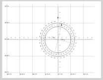
The sheets can be customized in every way and can even include a MN compass. Attached is a pdf example of a sheet I made for "100 Problems..." # 6-5. I've increased the scale to 30' per line as opposed to the standard 1° and I've included the MN compass for illustration purposes as it is not needed to solve the problem. I looked up the variation on the NOAA website for the problem location and date of 1993 Jul 7. I also increased the size of the compass rose. The default size is 1 and a half inches (rather small for my taste) or 2 Latitude lines, whichever is smaller. I increased it to 3 inches and it defaulted to the 2 Lat. line size.
Be warned, though: If you've never worked with postscript files (as was the case with me) it can be quite a challenge to get it to come out right. You can open the files in a text editor like notepad. You will see lots of postscript code and (thankfully) brief descriptions of what it all means. Just replace the default values with the values you need and save it. Preferably under a new name. To open/save the file as a pdf, you will need a plug-in that can read and convert .ps files into pdfs. I used "Postscript Viewer", a free plug-in for Adobe Reader available at download.cnet.com. (Note: There also appears to be some minor typographical errors in one or two of the internal descriptions.)
Once you get it all sorted out, you can produce high quality, pre-labeled custom plot sheets with very little effort. If you run into any problems, email me at yhshuh[at]gmail[dot]com and I'll gladly do what I can to help. :)
-Sean C.
P.S.
Here's a major tip: If you input a West Longitude, the default sheet will display the minutes increasing in an easterly direction. To fix this, find the following line toward the bottom of the .ps file:
% find the "minutes" part
60 mul angle exch sub cvi
/angle edef
angle 0 lt {angle 60 add /angle edef}
...and change it to:
% find the "minutes" part
60 mul angle exch sub cvi
/angle edef
angle 0 lt {angle neg /angle edef}
...et voila! (You can also set it up so that the Longitude labels alone will not be displayed so that they can be penciled in later.)
----------------------------------------------------------------
NavList message boards and member settings: www.fer3.com/NavList
Members may optionally receive posts by email.
To cancel email delivery, send a message to NoMail[at]fer3.com
----------------------------------------------------------------


