NavList:
A Community Devoted to the Preservation and Practice of Celestial Navigation and Other Methods of Traditional Wayfinding
Re: Venus, Jupiter, and the Moon
From: Frank Reed
Date: 2008 Dec 16, 22:44 -0800
From: Frank Reed
Date: 2008 Dec 16, 22:44 -0800
Two weeks ago, Dave wrote:
"If you grabbed your sextent (or your octant, or your quadrant, or your
protractor and string) and made the following near limb distance observations
at 20:00:00 UT 2008 Dec 1: Venus 1 deg 16.9 min, Jupiter 1 deg 35.3 min, what
island would you be near?"

This is a case where we can get a complete position fix by lunar distances
[NOTE: this was not how lunar distances were used historically]. The measured
lunar distances at known GMT will determine both latitude and longitude
without any measured altitudes --a fix without a horizon. There is a brute
force approach to the problem, but I've been trying to think of ways of
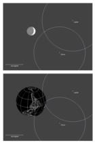
explaining how this works in a graphical fashion. And that's what you'll see
in the attached diagram.

We know from any nautical almanac that the Moon, at this instant of time, is
located directly above a point off the west coast of South America. Its GHA
was 74d 09.0' and its Dec was S22d 35.7'. If you were observing the Moon from
that location its apparent position in the heavens would be exactly the same
as its geocentric location. In other words, the given GHA and Dec would
correspond exactly to the GHA and Dec of the center of the Moon as observed
(except for a very small oblateness correction that we don't have to worry
about quite yet). The Moon, Jupiter, and Venus would make a nice triangle in
the sky as seen from this spot. The top half of the attached diagram shows
how this would look. But if we observe from any other spot on the Earth, the
Moon's position would be shifted relative to Jupiter and Venus. This is where
the measured lunar distances come into play...

The lunar distances from Venus and Jupiter allow us to fix the actual observed
position of the Moon's center in the sky. In the upper half of the diagram
below, I've drawn circles around Jupiter and Venus with radii equal to the
observed distances plus the Moon's semi-diameter (the scale is 0.5 minutes of
arc per pixel). And where those circles cross is where we would find the
center of the Moon as seen from our observing location. This observing
location can be graphically represented by taking the Moon out of the sky and
replacing it with a "ghost image" of the Earth with its continents and lines
of latitude and longitude. This image represents all of the possible
locations of the Moon's center as seen from every observing point on the
surface of the Earth. Note that the center of the projected Earth is exactly
that spot in the Pacific where the Moon would be straight overhead. Of
course, the Earth is reversed because if we move north, the Sun drops down to
the south as a result of parallax. Incidentally, the semi-diameter of this
ghost Earth is exactly equal to the Moon's horizontal parallax at this
moment: 54.2 minutes of arc. We can now examine the diagram and directly read
off our position, at least roughly. Eyeballing it, I estimate that the
position is in the Atlantic around 8 degrees South and 10 degrees West.
That's near Ascension Island, which is the answer to the puzzle, asssuming
I've done nothing wrong.

This analysis, projecting the circles and finding their intersection on the
projected face of the Earth, can of course be done rigorously, and I believe
that the math Dave posted a couple of years ago (when I first brought up this
idea of a position fix by lunar distances) does just that. We can also take
this approximate position from the graphical solution, 8 South and 10 West,
and use it as a starting point for a straight-forward clearing process. You
use this position as a "DR" in your favorite lunars clearing software (e.g.
this one: www.HistoricalAtlas.com/lunars) and then just walk your way to the
point where the calculated "errors" in the observed distances go to zero.
When I do that, I find that the observer's actual position was closer to 8d
South and 13d West --not far from that rough, graphical estimate.

Notice also that the diagram makes it easier to see the relative accuracy of
the position fix. Just by examining that "ghost Earth" you can see that the
resulting fix in latitude, in this particular case, is more accurate than the
longitude. Indeed the fix in latitude would be about as accurate as if the
Moon were in the zenith. That is, assuming measured distances accurate to +/-
0.1 minutes of arc, the latitude would be accurate to +/- 6 nautical miles,
approximately.

So that there is no misunderstanding, I am not proposing this "graphical
solution" as a general method for solving this particular problem. It's a
nice means of visualizing what's going on, and that's all.

-FER
http://www.HistoricalAtlas.com/lunars/


--~--~---------~--~----~------------~-------~--~----~
Navigation List archive: www.fer3.com/arc
To post, email NavList@fer3.com
To , email NavList-@fer3.com
-~----------~----~----~----~------~----~------~--~---


