NavList:
A Community Devoted to the Preservation and Practice of Celestial Navigation and Other Methods of Traditional Wayfinding
From: Tony Oz
Date: 2019 Oct 1, 05:35 -0700
Recently Frank has summarised the benefits of the "new CN" as:
calculation of the line of position, which is that you can plot it on common graph paper or equivalent, no special plotting sheets required
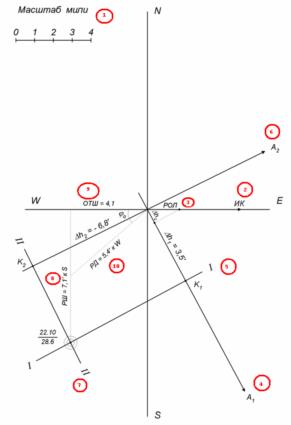
I am reading a Russian booklet for CN students and there is a nice trick, see the attached picture.
They teach to do a fix on a plain paper, not even square-lineated.
1) select a convenient scale, 1cm = 1nm is OK. Draw the NS and EW lines, the intersection is our AP
2) mark your TC (true course, ИК)
3) mark your distance covered between the two sights (РОЛ, log counter difference) to the scale
4) draw the azimuth of the first body, A1, drop a perpendicular on it from the РОЛ point, thus the Δhz is obtained, the altitude correction for the movement of the observer
5) from the end of the Δhz mark the intercept of the first body, Δh1, (the "toward" in the given example) draw the first position line I-I
6) draw the azimuth of the second body, A2
7) mark the intercept of the second body, Δh2, (the "away" in the given example) draw the second position line II-II
The intersection is the fix.
8) measure the latitude difference (РШ), notice its' displacement relative to the AP. Here is is РШ = 7.1' к S, (the latitude difference = 7.1' towards South)
9) measure the East-West displacement of the fix's point, ОШТ = 4.1 (literally - "отшествие", "departure")
Now is the clever bit:
10) from AP. draw a line at the angle of our estimated latitude until it cuts the РШ segment. The length of the РД segment is out longitude difference! :)
Notice its' to the West of AP.
Now just add the differences to the AP's coordinates - you have the fix position.
No plotting sheet required, only a protractor and a ruler.
:)
Thank you for listening.
Warm regards,
Tony
60°N 30°E


