Welcome to the NavList Message Boards.

NavList:

A Community Devoted to the Preservation and Practice of Celestial Navigation and Other Methods of Traditional Wayfinding

Compose Your Message

Message:αβγ
Message:abc
Add Images & Files
    Name or NavList Code:
    Email:
       
    Reply
    Re: Precomputation- was Sun lines was Moonrise video
    From: Gary LaPook
    Date: 2013 May 4, 02:22 -0700
    (I am attaching a pdf of this post to preserve the format of the table.)

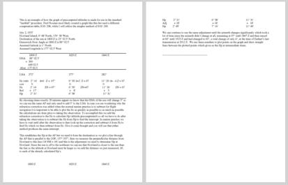
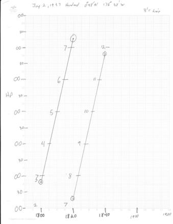
    This is an example of how the graph of precomputed altitudes is made for use in the standard
    “landfall” procedure. Fred Noonan most likely created a graph like this but used a different
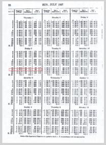
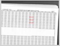
    computation table, H.O. 208, while I will utilize the simpler method of H.O. 249.

    July 2, 1937
    Howland Island, 0̊ 48' North, 176̊ 38' West.
    Declination of the sun at 1800 Z is 23̊ 02.5' North.
    Greenwich Hour Angle at 1800 Z is 89̊ 02.5'  
    Assumed latitude is 1̊ North
    Assumed longitude is 177̊ 02.5' West


                                                       1800 Z                1820 Z              1840 Z
    GHA      89̊ 02.5'     
             +  360
                 449 02.5
     Alon  -177 02.5


                                                      LHA     272̊                               277̊               282̊

                                                                          Hc (tab)   2̊ 14'    d=0   Z =  67̊          6̊ 50' d=2  Z = 67       11̊ 26' d= - 4 Z = 67
                                                                corr           0                         0                    0
                                                                          Hc           2̊ 14'            ZN = 67̊      6̊ 50'        ZN=67       11̊ 26'        ZN = 67
                                                           Ref.        +   17'                 +    8'                   +    5
                                                                Hp           2̊ 31'                6̊ 58'                     11̊ 31'


    By choosing times exactly 20 minutes appart we know that the GHA of the sun will change 5̊ so
    we can use the same AP and only need to add 5̊ to the LHA. In case you are wondering why the
    refraction correction was added when the normal marine practice is to subtract for flight
    navigation it is important to be able to plot the fix as quickly as possible so as much as possible
    the calculations are done prior to taking the observation. To accomplish this we add the
    refraction correction to the Hc to calculate Hp (altitude precomputated) so all we have to do after
    taking the observation is to subtract the Hs from Hp to find the intercept. In marine practice we
    have to wait until after the observation to then look up the correction and subtract it from Hs to
    find Ho which we then subtract from Hc. Give it some thought and you will see that either
    method produces the same intercept.

    This establishes the Hp at the AP but we need it from the destination so we plot a line through
    the AP that is parallel to the LOP, 157̊-337̊, then we measure the perpendicular distance from
    Howland to this line (18 NM = 18') and this is the adjustment we need to determine Hp at
    Howland. Since the sun is off to the northeast we can see that Howland is closer to the sun than
    the line so the altitude at Howland must be larger so we add the distance we just measured, 18',
    to each of the already calculated Hp’s.


                                                     1800 Z                  1820 Z              1840 Z
                                                                Hp           2̊ 31'                6̊ 58'                     11̊ 31'
                                                                Adj.      + 18'                     + 18'                      +   18'
                                                                Hp          2̊ 49'                 7̊ 16'                     11̊ 49'

    We can continue to use the same adjustment until the azimuth changes significantly which took a
    lot of time since the azimuth didn’t change at all, remaining at 67̊ until 1847 Z and then stayed
    at 66̊ until 1923 Z and had changed to 63̊, a total change of only 4̊, at the time of Earhart’s last
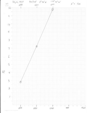
    transmission at 2012 Z.  We use these numbers to plot points on the graph and draw straight lines
    between the plotted points which gives us the Hp at intermediate times. The second graph just expands the altitude scale.

    gl


    -------------------------------------------------
    --- On Fri, 5/3/13, Gary LaPook <garylapook@pacbell.net> wrote:

    From: Gary LaPook <garylapook@pacbell.net>
    Subject: [NavList] Re: Sun lines was Moonrise video
    To: garylapook@pacbell.net
    Date: Friday, May 3, 2013, 8:08 PM


    Yes you can use any method you like to compute the altitudes at twenty minute intervals and then plot the precomputed altitudes on graph paper so that precomputed altitudes for intermediate times are instantly available. HO 218 is the forerunner to HO 249 and it is divided into two sections, with one section for selected stars. You get similar results with HO 214, HO 249, HO 229 and the short trig methods, HO 208 (Noonan's favorite)  and the Weems Line of Position Book. . You can also use th Bygrave slide rule and HO 211 which allow you to use the destination directly as the AP while using the other methods require a selected AP and then an adjustment to convert the computed altitudes at that AP to the altitudes at the destination. This can be done graphically, as stated in NIF using HO 218, or mathematically as done with the correction tables for HO 214. See attached files and:

    http://www.fer3.com/arc/img/105707.ho214-delta%20lat.pdf

    If you don't have HO 214 you can figure out your own "delta t "values since they are simply the difference between tabulated altitudes in HO 218,Ho 249,  (or HO 229 not as conveniently) for successive values of LHA.

    gl


    --- On Fri, 5/3/13, Bill B <billyrem42---net> wrote:

    From: Bill B <billyrem42---net>
    Subject: [NavList] Sun lines was Moonrise video
    To: garylapook---net
    Date: Friday, May 3, 2013, 1:09 PM


    Greg and Gary

    Thanks for the information on "running down a sun line." Greg's "Landfall" article gave me a frame of reference, similar to days of old making landfall where latitude was known and longitude was a best guess based on DR.

    I've read through the initial reference from Greg to Gary's work, and believe I understand the concept although I have no working knowledge of HO 208. I'll make the naive assumption other tabular methods may work as well (229 or 249).

    Being a visual learner, my next step is to use a universal mercator chart and follow through the example, which should help clarify the process in my mind (if an old dog can learn new tricks). Perhaps after that exercise I can follow up with any quasi-informed questions I may have.

    BTW It was interesting viewing a 1940's document that was "declassified".
    GCT (Greenwich Civil Time) vs GMT vs UT. I wish they would make up their minds :-)

    Bill B

    Bill B


    ----------------------------------------------------------------
    NavList message boards and member settings: www.fer3.com/NavList
    Members may optionally receive posts by email.
    To cancel email delivery, send a message to NoMail[at]fer3.com
    ----------------------------------------------------------------

    : http://fer3.com/arc/m2.aspx?i=123837

    Attached File: 123850.delta latitude correction tables.pdf (no preview available)

    : http://fer3.com/arc/m2.aspx?i=123850

    File:

      
    File:

      
    File:

      
    File:

      
    File:


    File:


    Reply
    Browse Files

    Drop Files

    NavList

    What is NavList?

    Get a NavList ID Code

    Name:
    (please, no nicknames or handles)
    Email:
    Do you want to receive all group messages by email?
    Yes No

    A NavList ID Code guarantees your identity in NavList posts and allows faster posting of messages.

    Retrieve a NavList ID Code

    Enter the email address associated with your NavList messages. Your NavList code will be emailed to you immediately.
    Email:

    Email Settings

    NavList ID Code:

    Custom Index

    Subject:
    Author:
    Start date: (yyyymm dd)
    End date: (yyyymm dd)

    Visit this site
    Visit this site
    Visit this site
    Visit this site
    Visit this site
    Visit this site