NavList:
A Community Devoted to the Preservation and Practice of Celestial Navigation and Other Methods of Traditional Wayfinding
Re: Advancing LOPs for precision fixes
From: UNK
Date: 2010 Feb 23, 02:53 -0800
From: UNK
Date: 2010 Feb 23, 02:53 -0800
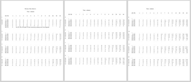
Since I had time on my hands I sat down with my calculator and computed
a "Motion of the Observer" correction table for the speed range of 1 to
12 knots which I have attached. If you need to make a more expansive
table then the process is easy. The top line for each speed is simply
the distance the ship travels in the stated time interval. the second
line is simply the entries from the first line multiplied by cosine 20
degrees. The same method is used for subsequent lines.
The sign convention is for advancing an LOP and is to be applied to observed altitude, simply add one more line to your sextant correction form. If you are retarding (oops! the "R" word) an LOP you must reverse the sign. If you are using flight navigation procedure and applying the correction to computed altitude you must also reverse the signs. If the azimuth to the body for the LOP to be advanced is ahead of the vessel, relative azimuth (ZN-TR) 0 to 90 then the sign is plus and if the azimuth is behind the vessel, 90 to 180, the sign is minus.
For intervals greater than ten minutes you simply add the values that total to the time period to advance the LOP. This might introduce some rounding error but this should not cause a significant problem since the accuracy of the DR will also be deteriorating as the time interval increases.
gl
Gary LaPook wrote:
On my recent Atlantic crossing I wanted to take sights and produce fixes that were as accurate as possible in order to gather data on celnav accuracy. It is common practice to ignore the movement of the ship during the time period needed to take a round of sights but since the ship was sailing at ten to twelve knots I decided that I would take this movement into account and advance the lines even for short periods. At twelve knots the ship moves one nautical mile every five minutes, one-tenth of a mile every thirty seconds. After using the marine practice and doing this graphically a few times I decided to switch to flight navigation practice and account for the movement of the ship by mathematically adjusting the LOP. I wrote about this before in discussing flight navigation so go to the following links to those prior postings for a complete discussion of how this is done. But since the Motion Of Observer (MOO) tables in H.O. 249 are for much higher ground speeds I had to create my own such tables for use on the ship. Attached are three photos of the table I created. The top of the table is for a speed of ten knots. Across the top is minutes that the LOP should be advanced. I had planned to compute values for each half knot but decided that such precision was not necessary so I only did the computation for whole knots, 10, 11 and 12.
I first computed the data for ten knots. The first two columns list the relative azimuth (ZN-TR) of the LOP to be advanced. I selected an interval of 20 degrees, 0, 20, 60, 80 and 90 for bodies ahead of the vessel with a plus sign (+) and 100, 120, 140, 160 and 180 for bodies behind the vessel with a minus sign (-) for applying the adjustment to sextant altitude. The values for 90 degrees are always zero so I omitted this for the other speeds. I also decided that the values I calculated for ten knots to one-hundredths of a minute of arc was gilding the Lilly so only listed them to one-tenth of a minute for the other speeds. The computation is easy. For 0 and 180 relative azimuths the adjustment is simply the distance covered by the ship during the period of time. For other relative azimuths you simply multiply the full value by the cosine of the relative azimuth.
Note the signs of the adjustments are for applying the adjustment to sextant altitude. This is opposite to my prior posts where the signs of those adjustments were for applying them to computed altitude which is the normal procedure in flight navigation. Making the adjustment to sextant altitude works well for marine practice in which the timing of the sight is random and is not preplanned and you only need to add one more line to your sextant correction form.
Give it a try and you will see that it is easier to advance LOPs this way and it is as accurate as the more traditional method.
http://www.navlist.net?i=105937&y=200807
http://www.navlist.net?i=105938&y=200807
https://navlist.net/img/105924.ho%20249%20extracts%20.pdf
gl


