NavList:
A Community Devoted to the Preservation and Practice of Celestial Navigation and Other Methods of Traditional Wayfinding
From: Geoff Hitchcox
Date: 2024 Jun 10, 05:45 -0700
Frank, is the first message in this thread a "Trick Question" ;-)
When making a Horizontal Sundial, the Gnomon needs to be at an angle to the flat surface equal to the latitude of the installation.
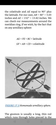
However the 'reference surface' on an Armillary Sundial is the equatorial armilla (Latin for ring) which is aligned parallel to the Earth's equator and thus the axis of rotation, and therefore local latitude. The gnomon must therefore be at an angle of the co-latitude, as shown in the diagram attached from Chapter 17 in the book "Sundials" by Albert Waugh (1973).
Regarding the two photos you took of the Mystic Sundials, armillary and vertical, back in April '24, here is my analysis.
Treworgy Sundial Coordinates = 41° 21.741' N, 71° 57.8292' W.
Solar Noon = 16:45:32 UT at Sundial on the 26 Apr 2024.
Photo taken at 26 Apr 2024 14.09.10 EDT = 18:09:10 UTC (1:23:38 after Solar Noon).
I would say the Armillary is about "10 minutes fast", and the Vertical "on time".
Solar Noon = 16:45:15 UT at Sundial on the 28 Apr 2024.
Photo taken 28 Apr 2024 16.35.30 EDT = 20:35:30 UTC (3:50:15 after Solar Noon).
Again, I would say the Armillary is about "10 minutes fast", and the Vertical "on time".


