NavList:
A Community Devoted to the Preservation and Practice of Celestial Navigation and Other Methods of Traditional Wayfinding
From: Frank Reed
Date: 2017 Oct 19, 17:30 -0700
Robin Stuart, you wrote:
" At that time the interpolated Flightaware data gives a latitude, longitude of 30.3629°, -134.5397°."
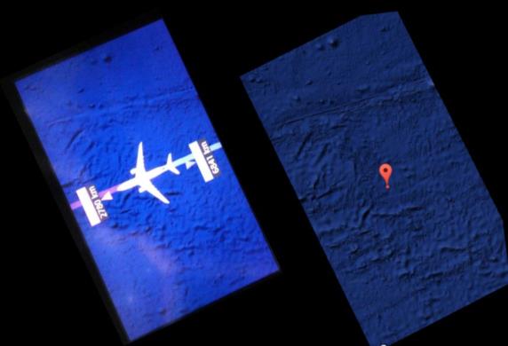
I took these coordinates and dropped them into Google Maps. When you switch to so-called "satellite view" over ocean, it shows ocean bathymetry. You can see ocean bathymetry in your photo of the in-flight display, as well, and it's a near-perfect match for the bathymetry that I see in Google Maps, after you rotate so that the plane is flying WSW. In the image below, the capture from Google Maps is on the right with north up. I clipped it to map the approximate region in the in-flight display. Look at the various linear features and especially the pattern of seamounts near the top of the pair of images. It's a match. This at least confirms that the in-flight system was using the actual position of the aircraft for its live plotting even in the middle of the flight over open ocean.
Frank Reed


