NavList:
A Community Devoted to the Preservation and Practice of Celestial Navigation and Other Methods of Traditional Wayfinding
From: Peter Blaskett
Date: 2023 Nov 12, 23:15 -0800
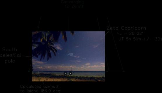
My revised estimate of time is UT 5h 51m +/- 1m
See final geometry drawing attached
These points are relevant to how close that time might be to reality.
1 The picture has been cropped. This is BAD.
Good information has been thrown away.
The black cross indicates the centre of the given pic.
The calculated Principal Point (PP) is not coincident.
The height of the calculated PP is fairly good. About +/- 4' arc,
but location L-R is problematic. The cropping from the left and
the right are probably not equal. The cropping top and bottom are
definitely not equal. This could amount up to maybe 15' arc L-R.
2 The camera lens has distortion.
(The red curve shows the imaged horizon. This would be a
straight line if no lens distortion).
This cannot be modelled, and is not accounted for.
3 The picture has some rotation CCW about the PP.
(The ends of the horizon are not level).
This could amount to 6' arc and is not corrected.
4 Dip of the horizon is about 3' of arc and is not accounted for.
It is small in relation to other error sources.
5 Refraction would be about 2' arc, but is not accounted for.
6 Errors in measurement are small, but +/- 1 pixel (about 2' arc
per pixel)
7 The star Zeta Cap is selected because its polar distance is about
as big as can be found in this pic. So dH/dT is largest. We are
after the best time we can get.
8 The final calculated azimuth to the island is in agreement with
that measured on the island chart. This indicates the location
of the calculated PP is in fair agreement with the true position.
The final measured azimuth of Zeta Cap is 251 30'.5, whereas by
Stellarium at the time above it is 251 33'.0
Addendum for Kermit.
You have used a short line; longer is better. Measuring in the picture I get :-
Peacock - Alnair angle 20.045
Ht Alnair 953.4
Ht Peacock 468.2
Ratio 2.0263
Peter B


