NavList:
A Community Devoted to the Preservation and Practice of Celestial Navigation and Other Methods of Traditional Wayfinding
From: Frank Reed
Date: 2015 May 21, 11:36 -0700
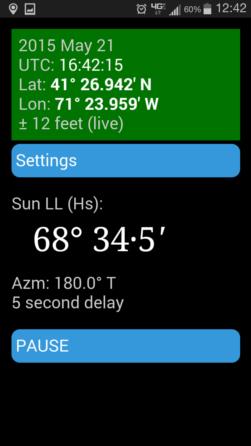
Here's a screenshot from one of my Android apps that appears to work very much like the app that Andres Ruiz posted about yesterday. I created this for my classes this Spring, but I see it in a rather different light. Yes, it's a sight-training tool, but any such tool also offers a real navigational function. This app provides the azimuth of the Sun live, which is certainly useful, and it also allows an immediate check on the GPS signal which can confirm that the GPS position is valid within the usual margins of error of sextant sights. If the altitude you take with your sextant matches the the predicted sextant altitude, then you have a confirmation that the GPS position is at least not wildly wrong --you're not being spoofed by pirates, in other words. And the key feature of this sort of check is that it requires no paperwork whatsoever. You can shoot the Sun all day long and get meaningful navigational information with no further work. Once you enter your index correction, height of eye, and an optional correction to the device system time, the software does all the calculations, and the number it displays is immediately available for direct comparison with the observation taken right off the sextant. A "modern" celestial navigator does not need to turn back to stone knives and bear skins (see "mnemonic memory circuit") like H.O. this-and-that. A modern navigator should be able to use all available navigational information, including the Sun in the sky, and use whatever moden technology is available. If I can see the Sun, I should be able to decide as quickly as possible whether its altitude is consistent with my GPS position. Given a common marine sextant (not itself automated) and given the exceptionally low prices of handheld supercomputers (a.k.a. smartphones), we should always have available a live display of the Sun's current sextant altitude and its true azimuth. Oh, and yes, it's also nice for sight-training...
Copies of my app will be available sometime after June 1. Until then you'll have to salivate over the screenshot. Doesn't it look delicious? "Mmmm... Anti-spoof...."
Frank Reed
ReedNavigation.com
Conanicut Island USA


