NavList:
A Community Devoted to the Preservation and Practice of Celestial Navigation and Other Methods of Traditional Wayfinding
From: David C
Date: 2020 Apr 11, 19:45 -0700
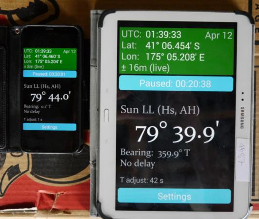
Cloud cover meant that I could not take a noon sight. I decided instead to observe the sun hanging. I placed my phone and tablet side by side. The app resolution is 0.1'. Every time the display on the tablet incremented I un-paused and then paused the phone. When the altitude on the tablet decremented by 0.1' I paused the tablet. My reaction time was probably about one second. The results are:
Start (phone) 0.1° T 79° 44.0' 002001 UT
End (tablet) 359.9° T 79° 39.9' 002038 UT
With a 0.1' resolution the sun hung for 37 seconds. With clear skies and a sextant with bertter optics than mine that should be ample time to take an accurate noon sight.
Note the slight difference in GPS positions. Immediately before taking the photo I had moved both devices to get better light and maybe the two devices settled down at a different rate. If my maths is correct 0.001' of latitude is approximately 6 ft - say 2m. The displayed latitude difference between the two devices is 6 * 2 = 12m. This s consistant with the errors quoted by the two devices - 8m and 16m. In case you are wondering the difference between 01 39 33 UT ad 00 20 01 UT was my lunchbreak.
I was using the AH setting so the maximum observed altitude was 39° 52'. From the Altitude correction table in the 1973 Nautical Almanac the SD + refraction correction is +14.9'. The actual altitude is therefore 40° 7'. The Sun Facts Pro app on my phone gives the maximum altitude as 40.2° or 40° 12'. Rounding error?


