NavList:
A Community Devoted to the Preservation and Practice of Celestial Navigation and Other Methods of Traditional Wayfinding
From: David Pike
Date: 2014 Dec 24, 10:35 -0800
Samuel Excuse me if I’m being a bit of a dim here, but it seems to me that you’re using a spherical trig formula devised for solving celestial problems on the celestial sphere, which really can be assumed to be a perfect sphere, to solve great circle problems on the Earth, which isn’t a perfect sphere, or even a perfect ellipsoid. That’s OK, so long as you’re prepared to reduce the number of significant figures in your final answer. I speak with all the confidence of someone who did an MSc exercise in this subject 14 years ago and hasn’t spent more than a few moments thinking about it since! It looks to me that for LHA, you’re using the change in longitude between the points A and B at each end of the great circle, so yes, seconds are reasonable (about 100yds at the equator). You must be substituting latitude of the observer for the latitude of point A and declination for the latitude of B.
Take care on lat and longs though. Believe it or not, a place can have more than one lat and long depending on which Datum it’s defined under. As the Earth is not a perfect sphere, or even a perfect ellipsoid, various map makers over the years have defined the shape of the earth to give the best fit for maps in the area they’re mapping. Some fitted long thin countries like GB and Italy best, others fitted short fat countries best. The default Datum for GPS is WGS 84, because that’s felt to be the best fit for the entire World, but with a hand held GPS like the Garmin GPS 12 you can select one from any number of Datums. In the UK, Ordnance Survey (the posh name for our large scale walking maps) use OSGB Datum, which is based on an Airey Spheroid. So you see a place can have more than one Lat and Long. Normally, the difference is rarely more than a few tens of meters, but for something like a super-tanker navigating a narrow channel with about six inches of water or even soft mud under her keel, using a different datum to the chart could spell disaster.
By Z, I assume you mean the bearing of B from A. Apart from academic reasons, I can’t see why anyone would want this to great accuracy unless they were thinking of aligning a directional aerial or launching a rocket possibly, because the bearing of B w.r.t. the meridian will change as you moved along the great circle.
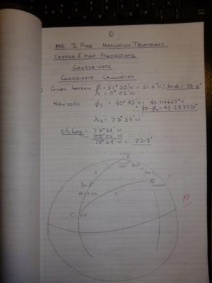
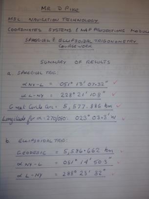
As an exercise, I was asked to compare the distance and bearings between London 51.30N 000.05W and New York 40.43N 073.59W using spherical geometry for a perfect sphere and ellipsoidal geometry for a particular spheroid. The difference in distance was about 9km, and the differences in bearings were between one and two minutes of arc. The summary is below. I see I got 100/100 from my supervisor; fourteen years later the maths looks like bagpipe music. Sorry about the significant figures Gary; I was celebrating the purchase of my first scientific calculator since ditching my slide rule. Dave


