NavList:
A Community Devoted to the Preservation and Practice of Celestial Navigation and Other Methods of Traditional Wayfinding
From: David Pike
Date: 2020 May 13, 13:27 -0700
Grace O'Farrell you wrote: I'm able to find the interception using LMT, date, a DR pos'n. Sextant alt, but I have some mental block trying to find LOP. For some reason after getting the Azi angle I cant determine if NS or EW.
Hi Grace
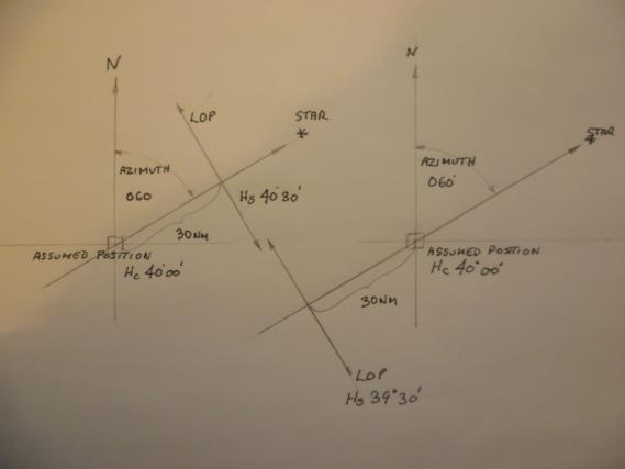
That would kind of depend upon what your professor’s been teaching you and why. I’m wondering, because NS or EW doesn’t normally come into it. I’m assuming you selected an assumed position and calculated an altitude and azimuth for the star. Then you just put your protractor over your assumed position with north at the top and draw a line in the direction of the azimuth. Then extend that line in the opposite direction away from your assumed position.
If your calculated altitude was 40 degrees, your calculated azimuth was 060 degrees, and your measured sextant angle was 40 degrees 30 minutes, it means your closer to the star than your assumed position. Just measure 30nm up your azimuth line and draw your position line perpendicular to your azimuth line.
If your measured sextant altitude was 39 degrees 30 minutes, it means your farther away from the point beneath the star than your assumed position is. Just measure 30nm in the 240 direction and draw your LOP perpendicular to your azimuth line. (See diagram) Whichever automatic method you might be using, I find drawing a diagram to see what's going on is always a great help.
If this is university stuff, it’s possible that they’ve got you calculating this using spherical geometry. In that case you need to know that the angle Z in the spherical triangle i.e. the angle opposite the side PX, isn’t automatically azimuth. It depends upon where P, Z, & X sit on the Earth’s surface, but that’s easy to correct. We can help you with that too. The best thing to do would be to post the question on NavList. Half a dozen guys will have posted a solution by next morning. Some with diagrams. DaveP


