NavList:
A Community Devoted to the Preservation and Practice of Celestial Navigation and Other Methods of Traditional Wayfinding
From: David Pike
Date: 2021 Dec 27, 06:19 -0800
Frank, Gary, Peter, Jeremy
I don’t remember mentioning great circles or I pads. I was intending to the fly Gentleman’s way using rhumb lines, a Douglas protector, nav-rule, pencil, and dividers. I chose Bermuda to St Helena carefully. It means the whole flight is over the sea, so there’s negligible terrain below the grid. Therefore, you can navigate on your North Atlantic Mercator chart as far as the Equator, turn it upside down, renumber the longitudes, and carry on navigating to St Helena. You’ll also need to mark in the position of St Helena and the position of any navigation aids and diversion aids you might need to use on the renumbered grid. You’ll need to renumber the longitudes to keep the first and second parts of the track a reasonable distance apart. They’ll end up parallel to each other. All you need to know is where you’ll cross the Equator.
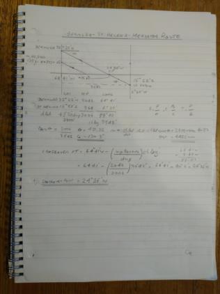
1. Simplest would be to lay your Mercator chart on flat surface (a tiled floor). Mark the position of St Helena as if its latitude was north instead of south. Measure the distance from the Equator to North Helena and mark that distance below the Equator on the flat surface to indicate real St Helena. Join this position to Bermuda with string. Where the string crosses the Equator is the rhumb line crossing point.
2. You could mark the Equator crossing point using meridional parts (mpt Bermuda/(mpt Bermuda + mpt St Helena)) x Chlong back east from long Bermuda. This and calculating a Mercator sailing gave me 4482nm, a track required of 130.3 (True), and a crossover point of 24deg 35’W.
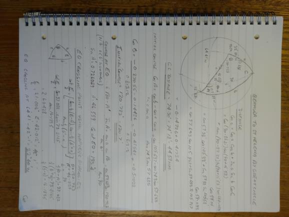
3. However, On 24th Dec we surmised that on a Mercator chart the GC must lie on the N Pole side of the rhumb line above the Equator and on the S Pole side below the Equator. Therefore, the GC and the rhumb line must cross at the Equator, and his must allow you to find the crossover point by spherical methods too. I did the globe and rubber band thing and got a crossover point of approximately 24 degrees west.
4. Then I used SAS and the law on cosines to get a GC distance of 4458nm. I used SSS and the law of cosines to get an initial course of 120.723 deg true. (90 – Lat Bermuda) is less than the 90 degrees from the pole to the crossover point on the Equator, so I used SSA and the law of sines to get the GC track required at the Equator as 133.4 deg true. I used Napier’s analogies to work out a crossing point of 22deg 40’W, but this could do with a bit more fettling.
Overall, going by rhumb line adds only 24nm (maybe less for the Terrestrial Spheroid), 3-5 minutes by airliner at high altitude. I could not prove conclusively within the accuracy of my calculations (a calc, upon a calc, upon a calc for a sphere versus Nories meridional parts for the Terrestrial Spheroid for the Mercator sailing) that the rhumb line and the CG cross at the Equator, but I got close. More work is required on this. Afterwards, I checked against Peter’s spreadsheet, and a couple of others online. All gave similar but slightly different results, especially for the crossing point.
However, the main problem is finding an airliner with sufficient range to reach St Helena from Bermuda, which has the performance to take off again from St Helena’s short runway. DaveP


