NavList:
A Community Devoted to the Preservation and Practice of Celestial Navigation and Other Methods of Traditional Wayfinding
From: David C
Date: 2016 Dec 2, 23:17 -0800
This is a bit of a ramble showing how one thing leads to another.............
While searching newspapers for photos of sextants I came across the following June 1914 article:
https://paperspast.natlib.govt.nz/newspapers/EP19140601.2.19
The cynic in me said that the real reason that Captain Blackburn wanted Captain Norton's letter posted was because it would help the sales of Blackburn's book (-;
Then I noted Norton's comment about taking sights of Canopus and Sirius and working them as ex-Meridians. This was at 5 30pm which assume is local time. In 1914 NZ was 11 1/2 hours ahead of GMT so LAN would have been sometime between 1200 and 1230 local time. Did Captain Norton really do two ex-meridians five hours after LAN?
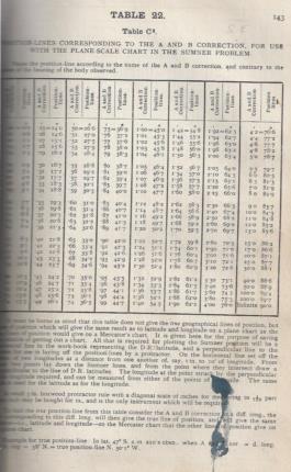
Norton mentioned using Blackburn's "ingenious Table C2". I have a 1923 edition of Blackburn's Tables for Azimuths, Great Circle sailing and Reduction to the Meridian. These tables contain the C2 tables (attached). Studying the explanation I concluded that the C2 table allows Sumners (and presumably intercepts) to be plotted on a plane rather than mercator chart. It is based on the A B C tables.
A+-B -> C -> azimuth on a mercator chart
A + B -> C -> C2 -> azimuth on a plane chart so a page in a workbook will do.
Getting back to Captain Norton.......... The inference is that the Canopus and Sirius sights were plotted as Sumners.
Glancing through the text in Blackburn's book I conclude that at the beginning of the 20th century Sumners and Mark St Hilaire methods were used interchangeably. Sometimes one sight would be worked as a Sumner, the other as an intercept. Why I do not know.
I have a pdf version of Cotter's A History of Nautical Astronomy. Puzzled about the 5 30pm ex-meridians I scanned the chapter on finding latitude. I discovered that (in theory) latitude can be found when the sun is on the prime vertical. The time t seconds (time)) for the sun to rise a seconds (arc) give latitude thus:
cos lat = 1/15 x a/t
I have the following sights:
085443 33° 47.6'
090323 35° 24.1'
Delta t 520 sec
Delta alt 96.5'
I suspected that the 8min 40sec interval was too large but decided to give it a try.
from which lat = 42° 4' ( gps 41° 06.50)
I am not suggesting that Captain Norton used this method - as I said this as a ramble.
Cotter suggests that the time for the sun to move one semi diameter be measured:
t = a / 15/cos lat = 16*60/15/cos 41 = 85 sec
Therefore next time I take a sight when the sun is on the prime vertical I will take additional sights at about one minute intervals.
Those who just study intercepts and 229 do not know what they are missing! That's enough for now (-;


