Welcome to the NavList Message Boards.

NavList:

A Community Devoted to the Preservation and Practice of Celestial Navigation and Other Methods of Traditional Wayfinding

Compose Your Message

Message:αβγ
Message:abc
Add Images & Files
    Name or NavList Code:
    Email:
       
    Reply
    Re: Cape Belsham
    From: Brad Morris
    Date: 2017 Jan 29, 12:43 -0500
    I went back to the chart 29104, for the purposes of defining Worsley's geographic error.

    I've updated my copy of 29104 to put the place names right.

    Using the coordinates that Worsley wrote in his log (and Reginald James wrote on his chart) we have S61°4' W54°50'.  I placed that location on the chart, using standard plotting tools.  It is the small circle with cross just to the NNE of Point Wild.

    See image.

    Measuring the distance from where the point is today, to where Worsley thought it,  Worsley is to the north 1'15" and to the east 1'E.

    Converting the latitude error to nautical miles we have
    1'*cos (61)=.484 nautical miles east
    The longitude is along a great circle, no conversion truly needed
    1'15"=1.25 nautical miles north

    A little triangle solution 
    (1.25^2 + .484^2)^.5= 1.34 nautical miles total error.

    Brad


    On Jan 28, 2017 7:30 PM, "Brad Morris" <NoReply_Morris@fer3.com> wrote:

    Robin

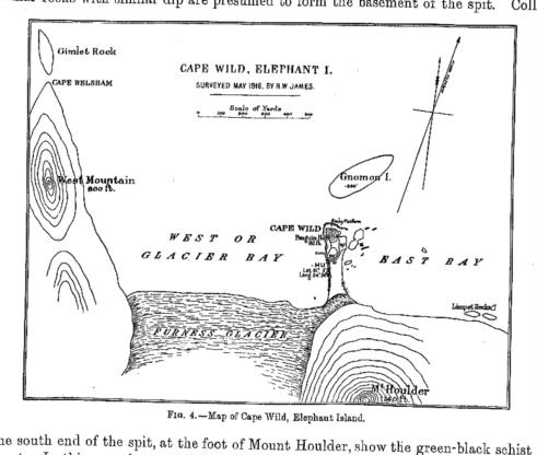
    I have found a better image of the encampment on Elepant Island.

    It appears in one of the papers by James Wordie (another strandee).  The better image is attached, please take a look.

    If you look in the upper left hand part of the image, right by Gimlet Rock, you will find a point labeled "Cape Belsham".  This chart was created by Reginal James in 1916 and published in James Wordie.  There can be no more of an authoritative source of what point the men considered to be Cape Belsham, than the men themselves.

    Needless to say, it is NOT the "N. point of Elephant Island", not by several miles.  The landmass referred to by the Ethiopics does not appear to be the landmass selected by Worsley.

    I retract my earlier discussion as to how the chronometer error was determined.  The discrepancy among the Ethiopic lat/long, Worsley's determined lat/long and how it determined his chronometer error remains unresolved.  Worsley, upon arriving at South Georgia Island is perfectly aware that his chronometer adjustement was not sufficient. 

    The determination of the CE remains the central problem to the navigation.  In your own words Robin, Worsley would have known if the James Caird was half way up a mountain, stranded on a glacier. 

    Brad


    Attached File:


    File:


    Reply
    Browse Files

    Drop Files

    NavList

    What is NavList?

    Get a NavList ID Code

    Name:
    (please, no nicknames or handles)
    Email:
    Do you want to receive all group messages by email?
    Yes No

    A NavList ID Code guarantees your identity in NavList posts and allows faster posting of messages.

    Retrieve a NavList ID Code

    Enter the email address associated with your NavList messages. Your NavList code will be emailed to you immediately.
    Email:

    Email Settings

    NavList ID Code:

    Custom Index

    Subject:
    Author:
    Start date: (yyyymm dd)
    End date: (yyyymm dd)

    Visit this site
    Visit this site
    Visit this site
    Visit this site
    Visit this site
    Visit this site