NavList:
A Community Devoted to the Preservation and Practice of Celestial Navigation and Other Methods of Traditional Wayfinding
From: Hanno Ix
Date: 2014 Nov 25, 21:09 -0800
CELESTIAL NAVIGATION: 19TH CENTURY METHODS
Coming up Saturday and Sunday November 1 and 2 at Mystic Seaport in Mystic, Connecticut, I'm running my class in celestial navigation as it was practiced in the 'Age of Sail'. We'll focus on actual observations made aboard the whaleship Charles W. Morgan on its multi-year voyages to the Pacific to hunt whales in the 19th century. Participants will learn all about sextants, Noon Sun sights for latitude, and traditional time sights for longitude. We'll work with modernized versions of traditional log tables to do the calculations, but we'll also see how to do the work by calculator. All of this is practical, or at least "practicable" in the 21st century, too, and we'll also emphasize how to use these methods to cross an ocean today.
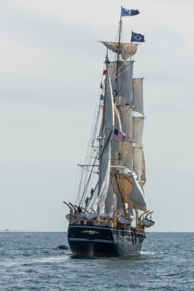
Details here: http://www.reednavigation.com/c19-class/The photo, taken July 11, 2014 a few miles north of Cape Cod, is from the "38th Voyage" of the Charles W. Morgan. On this voyage leg I was navigating by sextant while everyone else was busy watching those pesky whales. Silly whale tourists: "Oh look, a giant marine mammal swimming majestically alongside our restored whaleship... again!" As if that's more interesting than spherical trigonometry calculations performed with logarithm tables. Sheesh. ;)
Two weeks after this class, we're offering our "lunars" class again. This "19th century methods" class is an excellent introduction for the lunars class if you're considering joining in on that (lunars class details). I'll post a more specific description of that soon.
-FER
Attached File:
(f1-Stell-day-1-whale-to-port.jpg: Open and save)


