NavList:
A Community Devoted to the Preservation and Practice of Celestial Navigation and Other Methods of Traditional Wayfinding
From: Brad Morris
Date: 2020 Jan 12, 18:41 -0500
I am a beginner in the study of celestial navigation, despite being of retirement age, and this is my first NavList posting. My initial celestial navigation project was to try to determine latitude by noon sun, to start with an easy measurement (particularly when carried out from the boardwalk in Belmar, New Jersey, rather than aboard a sailboat). The results were very encouraging, since the measurement error with respect to GPS latitude was only 3.3 minutes of arc, probably a case of beginner's luck.
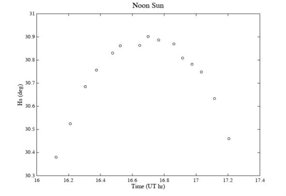
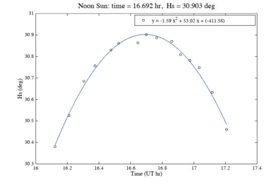
I followed the method I read in a couple of textbooks, which recommend taking a series of measurements before and after local apparent noon. What I did not read is which type of curve should be used for fitting these data points. As the data points seemed to describe a parabola (figure NoonSun), I used a polynomial of degree 2, which has the advantage of being easy to deal with (figure NoonSunFit). It also allows a calculation of the time at which the curve reaches its maximum, and of the altitude reached at the maximum.
My question is: does Sun altitude as a function of time describe a parabola? Or another curve? Or it doesn't matter as long as the fit is acceptable? Many thanks in advance for your input.


