NavList:
A Community Devoted to the Preservation and Practice of Celestial Navigation and Other Methods of Traditional Wayfinding
From: Frank Reed
Date: 2022 Jan 31, 18:10 -0800
It's Valentine's Day. You've broken down. You weren't going to pull out your sextant. You resolved when you boarded the giant cruise ship at Port Canaveral that you would partake of hedonistic pleasures and a thought-free existence --a few quiet days with your partner. But somehow your sub-conscious knew better and packed a sextant for the trip... It is time.
You're sailing a couple of dozen miles north of the northern-most end of Eleuthera Island in the Bahamas on 14 February 2022, heading slowly east. You roughly estimate your position as 25.5° N, 76.0° W. You're going to enjoy an evening of star sights, despite the drunken debauchery all around you and the insanely bright lights covering the cruise ship from stem to stern. But first you need your height of eye. You specifically avoided determining that before boarding in keeping with your plan to "have fun". But now you need it. There are various ways to do this, but you realize in the late afternoon that you can figure it out by a pair of sights of the Sun and the Moon.
In celestial navigation, each sight is a bit of data. Two bits of data go into the calculations, and two bits of data come out. Normally the output data are latitude and longitude. Instead, with this pair of sights, you will determine your height of eye and your longitude (to some level of accuracy under some assumptions, which you can puzzle over).
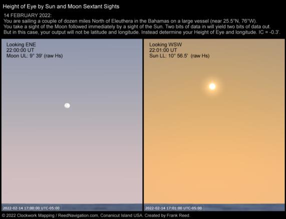
Your sextant has an index correction of -0.3'. At 22:00:00 UT exactly, just to make things a little easier on yourself, you shoot the Moon and get a raw sextant altitude (Hs) of 9° 39'. This is, necessarily, a Moon Upper Limb observation. You write that down while you're running across deck to shoot the Sun. At 22:01:00 UT exactly, you measure the altitude of the Sun (Lower Limb, of course --like 99.99% of all Sun sights), and you get 10° 56.5' (Hs).
So what is your best estimate of your longitude? And what is your best estimate of your height of eye? The details as I have written above are also spelled out in the attached image.
Frank Reed
Clockwork Mapping / ReedNavigation.com
Conanicut Island USA


