NavList:
A Community Devoted to the Preservation and Practice of Celestial Navigation and Other Methods of Traditional Wayfinding
From: Gary LaPook
Date: 2011 Feb 12, 00:55 -0800
(I am also attaching this as a PDF file.)
I have examined Amelia Earhart’s navigation from Natal to Dakar near the beginning of her
flight around the world. Although this leg took place well before the flight from Lae to Howland,
it has been seen as relevant in unraveling the final mystery as it may shine light on the
interaction between Earhart and Noonan. But just like the rest of this story, the information
concerning the flight across the Atlantic is confusing, contradictory, incomplete and difficult to
interpret.
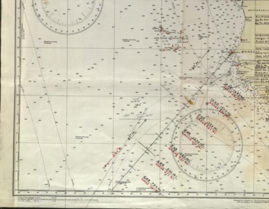
I obtained a copy of Noonan’s actual chart that he used on the flight from Natal to Dakar. The
original is kept in the archives of Purdue University and I had the archivist scan it for me.
(TIGHAR sells a copy of what it claims is this chart but it IS NOT an accurate copy of the actual
chart, markings have been erased and, even more inexplicably, it has added markings and
notations, so its provenance is suspect.)
Earhart and Noonan departed Natal, Brazil at 0615 Z (Greenwich Mean Time) on June 7, 1937
for Dakar and landed thirteen hours and twelve minutes later at 1927 Z in Africa but at Saint
Louis, about 116 SM north of their planned destination of Dakar. ( Earhart said it was 163 SM.)
Amelia explained it this way:
“When we first sighted the African coast, thick haze prevailed and for some time no position
sight had been possible. My navigator indicated that we should turn south. Had we done so, a
half hour would have brought us to Dakar. But a "left turn" seemed to me in order and after
fifty miles of flying along the coast, we found ourselves at St. Louis, Senegal.” (Last Flight, page
119)
A careful examination of the actual chart work that Noonan did on this flight might further
explain what actually happened. (I have also examined Noonan’s chart for the flight from
California to Hawaii so I am familiar with his methodology.)
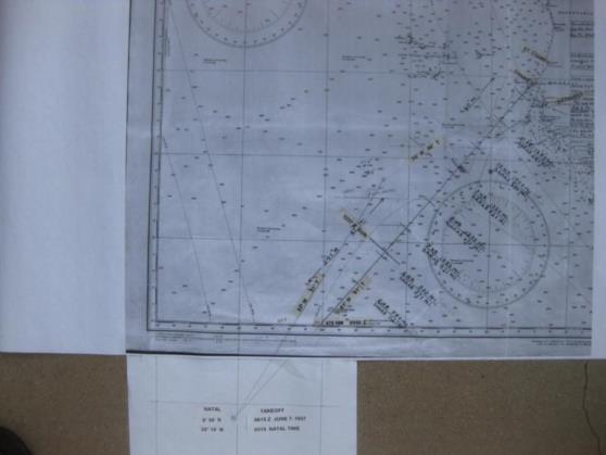
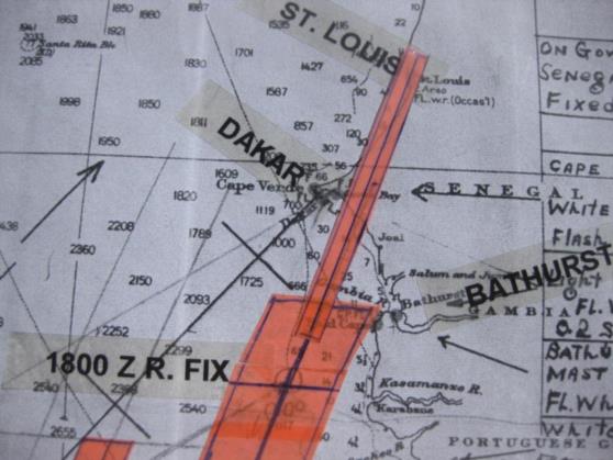
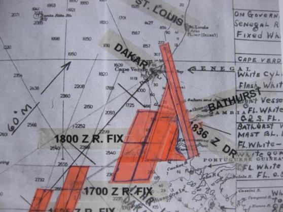
I have attached a copy of the southwestern portion of “North Atlantic Ocean, Southeastern Sheet,
(1930)”, the marine chart used by Noonan. I have also attached a black and white large scale
printout of this chart on which I have made annotations. (See maps 1 and 2 and image 3.) This
chart starts at the equator. The first thing you notice on the chart is the preplanned course line
marked at hourly intervals, every 150 statute miles (SM) since the planned ground speed was
150 mph. The last mark is at the 1800 SM point at 12 hours. From this last mark to Dakar is 71
SM for a total of 1871 SM, making the estimated flight time twelve hours and 28 minutes and
the estimated time of arrival (ETA) 1843 Z. (Earhart’s clock was set to Natal time which is three
hours slow on GMT and her notes are in Natal time. I have converted them to GMT as this is the
time used by Noonan for his notations on the chart. I also use nautical miles (NM) as these are
the miles used by Noonan and all navigators. A nautical mile is 15% longer than a statute mile so
the distance from Natal to Dakar is 1627 NM. Since navigators use nautical miles for distances
they also use knots for speeds, one knot being one nautical mile per hour. The planned ground
speed was 150 mph which is the same as 130.4 K (knots).)
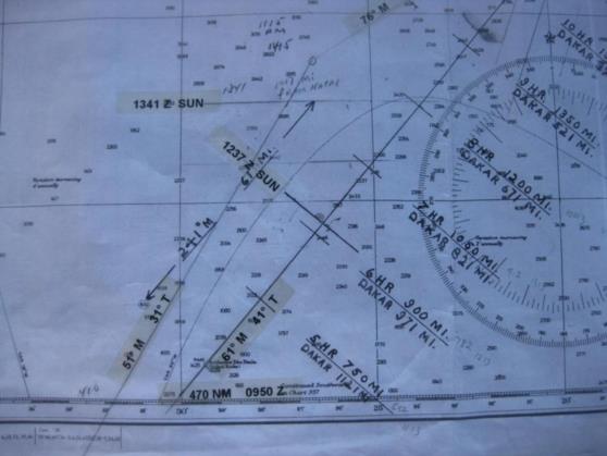
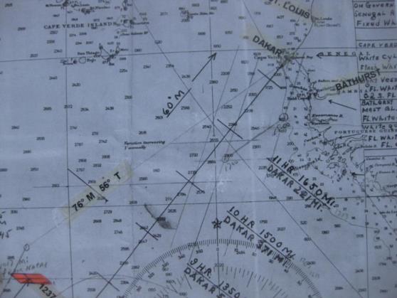
The true course runs 41̊. Parallel to the course line you find the notation “241̊ M — 61̊M” and
further along “60̊ M.” This shows the magnetic course for use with reference to the magnetic
compass and is the true course adjusted for the magnetic variation of 20̊ west for the first part of
the flight and 19̊ west for the final portion.
Further to the west is another line running 31̊ T (true), 051̊ M. On my annotated chart I have
attached an extension at the bottom so that I could plot the departure airport at Natal at 5̊ 54'
south, 35̊ 15' west. Noonan did the same thing as we can see the two lines already mentioned
run across the neat line onto the border and converge on Natal. You can see Noonan’s notation
next to the leftmost line of “410" which is the distance in NM from Natal to the equator along
this line. I added a similar notation for the course line which crosses the equator 470 NM from
Natal.
Earhart wrote that they crossed the equator at 0950 Z (6:50 a.m.) in her notebook. This was
based on dead reckoning (moving the position based on the course flown and the distance
covered) and we can determine that they were following the course line and not the leftmost line
by this notebook entry. The flying time to this point was 3:35 which at 130.4 K means they had
traveled 467 NM which is consistent with the distance along the course line to the equator. Had
they been following the leftmost line they would have crossed the equator 26 minutes earlier at
0924 Z.
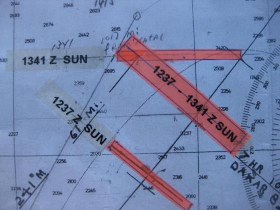
At 1237 Z Noonan measured the sun’s altitude with his Bendix bubble octant (a kind of a
sextant) through the cockpit windshield as the sun was almost directly in front of them and he
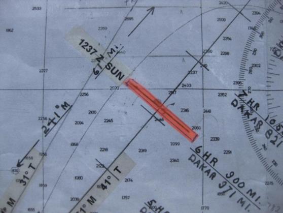
would have measured the altitude as 65̊ 34'. After doing the appropriate computations, Noonan
drew a line of position (LOP) across the course line running 130̊ T - 310̊ T which was at right
angles to the azimuth of the sun which was 040̊ T. (See image 4.) Although Noonan didn’t write
the time of this sight down on the chart, we know it was 1237 Z as it was at that time that the
azimuth of the sun was 040̊ T at that point on the course line. Any earlier and the azimuth
would have been more,, any later and the azimuth would have been less. (Contrary to what is
observed in the U. S., from their location the sun moved counter-clockwise across the sky.) The
LOP represented their most probable location, they should be somewhere along this line. This
LOP is 809 NM from Natal and the elapsed time was 6:22 so the ground speed had been 127 K
(146 mph.)
Since there is some uncertainty in celestial observations, the LOP is actually a band 14 NM
thick extending 7 NM on each side of the LOP. It is very unlikely that a sextant reading will
produce an LOP that is more than 7 NM in error so this band should contain virtually all possible
locations of the plane and the plane is actually most likely to be nearer the center than the edges.
However, this one LOP couldn’t give Noonan his exact location as they could have been
anywhere along it but he could put some bounds on this uncertainty. (This is no more
mysterious than your saying that you are somewhere on Second Avenue.) A generally accepted
rule used by flight navigators is that the uncertainty of a dead reckoned position increases as
10% of the distance covered since the last fix. They had flown 809 NM from Natal so the
uncertainty extends 80.9 NM along the LOP in each direction from the course line making the
LOP 162 NM long and 14 NM thick. I have indicated the extent of the uncertainty band on the
hi-liter tape. (See image 5.)
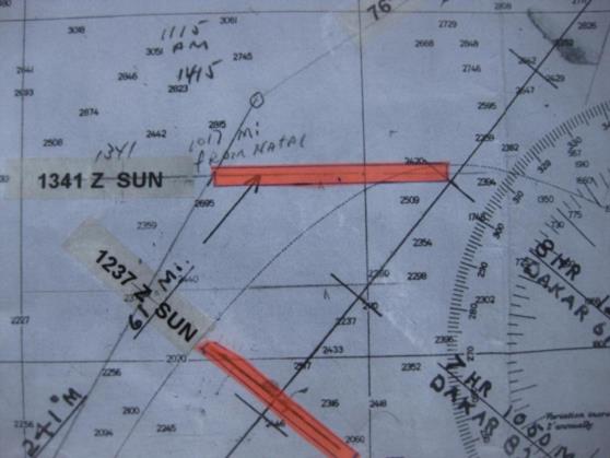
At 1341 Z Noonan took another observation of the sun, this time from the left side cabin
window. He would have measured 74̊ 48' with his octant. After computation, he drew an LOP
running 90̊ T - 270̊ T meaning the azimuth to the sun was straight north, within a couple of
minutes of noon. At this point Noonan had reason to believe that he was west of the course line
at a longitude of 25̊ 35' west. We know this because at 1341 Z the Greenwich Hour Angle
(GHA) of the sun, the same as its longitude, was 25̊ 35', Noonan would have found this in his
Nautical Almanac. Only if the airplane’s position was at the same longitude as the sun would the
sun’s azimuth be straight north. If they were still on the course line then noon would have
occurred earlier at 1335 Z at a longitude 24̊ 05', about 90 NM further east. Noonan most likely
had determined that they were to the left of course by measuring the plane’s drift with his Mk 2
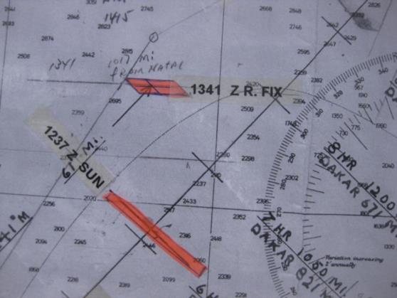
driftmeter. Similarly to the first LOP, this LOP was also 14 NM thick but was 200 NM long as
they were now about 1000 NM from the last fix, the departure airport of Natal. Noonan drew this
LOP and labeled it “1341" and extended it so that it crossed the course line and also the leftmost
line running at 31̊ T. (See image 6.) Since this LOP runs straight east and west it defines a
latitude of 7̊ 37' north. This LOP crosses the course line 1070 NM from Natal and also crosses
the leftmost line only 943 NM from Natal. We can make an estimate of where along the LOP the
plane was. The plane had been flying for 7:26 so if they were on the leftmost line then their
average ground speed had been 127 K (146 mph.) If they were following the course line then
their ground speed would have been 144 K (165 mph) which is also reasonable with only a 14 K
tailwind, which would not be unusual. Earhart wrote in her notebook that they were flying at
6,000 feet, the temperature was 60 ̊ F, and the indicated airspeed was 140 mph thus making
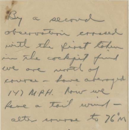
their true airspeed 155 mph, 5 mph faster than their planned speed. Noonan sent Earhart a note
saying that they had averaged 147 mph but also saying that they now had a tailwind so that
doesn’t help much. (I have attached a copy of this note which is kept at Purdue, see note 1.)
The note also said that by crossing the 1341 Z observation with the first observation that he had
determined that they were north of course, to the left of course. Noonan was talking about a
standard navigational method of advancing the earlier LOP to the time of the second LOP and
taking the point that they cross as a “running fix.” A normal “fix” is at the intersection of two
LOPs taken at the same time which is no different than stating that you are at the intersection of
Second Avenue and Main Street. A running fix is the same as your friend calling you on his cell
phone and saying “I have been driving east of Second Avenue and I passed Main street about a
mile back.” A running fix has more uncertainty than a normal fix since the navigator must
estimate the movement of the airplane between the two observations and advance the earlier
LOP as though it had been attached to the plane. Any error in this estimate will result in a similar
error in the running fix. This is where the skill of the navigator is critical and why navigation is
also an art and not entirely a science.
Even though Noonan said that crossing the two LOPs showed them to be to the left of course and
that they now had a tailwind, he did not actually do the chart work to do this but apparently just
used his experience to estimate where the running fix would have been. On my chart I have done
the chart work and have advanced the 1237 Z LOP along the course line (maintaining its
alignment) 139 NM, the distance that would have been covered by the plane at the flight planned
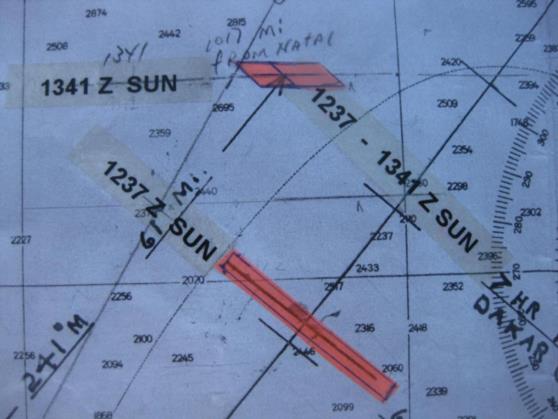
130 K speed for the 1:04 period between the two sights. The first LOP was originally 14 NM
thick but the uncertainty increases at a rate of 10% of the distance the LOP is moved adding an
additional 13.9 NM (call it 14 NM) to each side of the original band of uncertainty making the
band or uncertainty 42 NM thick after it is advanced. (The length also increases by the same
ratio but this is not important at this point.) The intersection of the 1341 Z LOP with the 1237 Z
advanced LOP marks the running fix and the overlap of their bands of uncertainty contains the
actual position of the aircraft. This area is 14 NM thick north to south (the uncertainty of the
1341 Z LOP) and extends 60 NM east and west (since the lines cross at an angle), constrained by
the overlap of the 1237 Z advanced LOP. (See image 7.) In image 8 I have removed the excess
length of the two LOPs leaving only the overlap which is the total area of uncertainty of the
running fix. (See images 8 and 9.) A navigator takes the actual intersection of the LOPs as the
running fix and does not draw in the uncertainty bands but he keeps them in mind and knows
that they grow bigger as time goes on.
The normal procedure is to mark the running fix on the chart and then lay off the new course
from that point to the destination but Noonan didn’t do this, why? He may have had some doubts
about the accuracy of the earlier sight and the rest of his chart work supports this theory. If we
look where the two LOPs intersect the course line we see that the distance between these two
intersections is 261 NM. For the plane to travel up the course line and cover the distance
between the two LOPs in 1:04 would require a ground speed of 245 K meaning a tailwind of 115
K which is impossible. So one of the LOPs is probably in error and Noonan apparently decided
that it was the 1237 Z LOP. Noonan advances the 1341 Z LOP three times to determine running
fixes and DR positions but never actually advances the 1237 Z LOP.
The next thing we see on the chart is a circle at the north end of the leftmost line labeled “1017
mi from Natal” and the time of “1115 AM, 1415” which gives the Natal time and the
Greenwich Mean Time. From this point a line was drawn to Dakar on a course of 76̊ M (56̊
T), the heading that Noonan’s note instructed Earhart to turn to. So what did this all mean? The
leftmost line runs 31̊ T, exactly ten degrees to the left of the course line. I think what Noonan
was doing here is that he knew that they were drifting to the left of the course line but he also
knew that he had not drifted more than the ten degrees delineated by this line. He then knew that
if he assumed the worst case, that he was ten degrees off course to the left, and then figured the
course from that point directly to Dakar and with the plane anywhere to the east or south of the
1415 Z point, turning to the new computed course, 76̊ M, would guarantee that they would
intercept the coastline south of Dakar. The further chart work shows that this worked as
intended.
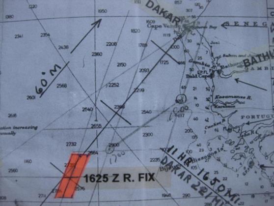
They flew on the course of 76̊ M and then at 1625 Z Noonan took another sun observation and
drew the resulting LOP on the chart. We know the time of this observation (it is not exact but
within five minutes) by the azimuth of the line and the distance on course that the plane traveled
between this line and the same line advanced to 1700 Z. If you extend the course line back from
the 1800 Z position though the 1700 Z position until in intersects the 1625 Z line you will
measure 78 NM and based on their ground speed this would take about 35 minutes placing this
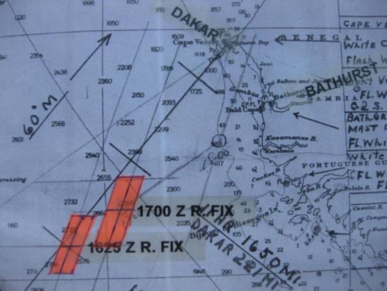
earlier sun line and sun observation at about 1625 Z. He did not label this LOP. He then
advanced the 1341 Z LOP to intersect the new LOP and formed the 1625 Z running fix, which is
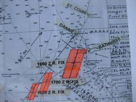
not labeled. (See image 10.) As before, the new LOP is 14 NM thick and runs 21̊ T since the
azimuth of the sun was 291̊ T. Since the 1341 Z LOP had been advanced for 2:44, a distance of
356 NM, the advanced 1341 Z LOP would have gotten about 71 NM thicker making it a total of
85 NM thick and this is in the north- south direction since this LOP itself ran east and west. I
have shown the resulting area of uncertainty on the chart. (See image 11.) These two LOPs were
then advanced twice to make the 1700 Z and the 1800 Z running fixes or DR positions. The 1625
Z LOP advanced to 1800 Z runs to St. Louis and nowhere near Dakar. (Elgin Long wrote that
Noonan actually took sun sights at 1700 Z and 1800 Z but the azimuths would have been
different if he had done so. Also, it was not Noonan’s practice to take sights on the hour as there
were no such sights taken on the much longer flight to Hawaii.) The areas of uncertainty
expanded each time these LOPs were advanced and I have illustrated these areas of uncertainty,
see illustrations 8,9 and 10. (This is not an important disagreement with Long. If Long is right
then the thickness of the uncertainty bands along the 1700 Z and 1800 Z LOPs were 14 NM
instead of getting wider as I have shown. My illustration shows the worst case. If Long is correct
then these positions are running fixes, if I am correct then they are actually DR positions) If you
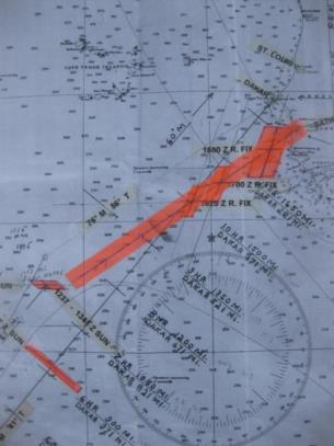
draw a line through these last three positions on a bearing of 256̊ M (the reciprocal of 76̊ M )
you will see that it takes you back to the 1341 Z running fix. This shows that the plane was
within the uncertainty area of the 1341 Z running fix when the course was changed to 76̊ M.
The plane was not at the 1415 Z circled position, Noonan only used that point as a worst case
and used it to calculate the course to follow that would assure him that they would intercept the
coast south of Dakar. (See image 14.) If this isn’t clear, what Noonan was doing was a way to
deliberately aim off (like at Howland) to the south to assure that he didn’t pass to the north of
Dakar. Had he measured the course from the 1341 Z running fix to Dakar he would have found
68̊ M but by measuring from an arbitrary point 60 NM further north he found a course of 76̊
M, eight degrees further to the south, which would then cause the plane to end up well south of
Dakar.
Up to this point all we have seen is perfectly normal flight navigation as practiced by tens of
thousands of flight navigators during WW 2 and by additional thousands of B-52 navigators up
to the end of the Cold War, only twenty years ago. But from this point Noonan’s navigation
becomes strange. Looking at map1 you can see that there had been a line parallel to and between
the 1700 Z and 1800 Z LOPs that ran to Dakar but this line had been erased. We can also see that
the 1800 Z LOP runs to St. Louis, not to Dakar. The 1800 Z running fix (or DR) is 110 NM
south of the coast and even the extreme northern limit of the band of uncertainty is still 47 NM
south of the coast so there is no possibility that the plane could have hit the coast north of Dakar.
From this position it is 215 NM to St. Louis and from the northern edge of the band of
uncertainty it is 152 NM to St. Louis. If they turned towards St. Louis at 1800 Z to travel along
the LOP on a true course of 21̊, which is a magnetic course of 40̊, they would have crossed the
coastline 37 NM to the east of Dakar and even if they were at the extreme western edge of the
band of uncertainty, which is unlikely, they would still have hit the coast 10 NM east of Dakar.
(If Elgin Long is correct, that Noonan took an observation of the sun at 1800 Z, then the width of
the band of uncertainty would be greatly reduced, so even from its western edge, they would
have hit the coast 30 NM east of Dakar.) (See image 15.) The course to Dakar from the 1800 Z
position is 21̊ M (002̊ T) and the distance is 120 NM. Even from the nearest edge of the band
of uncertainty it is still 65 NM to Dakar. Flying along the 1800 Z line, when they hit the coast
they could easily have followed it to Dakar if they had wanted to go to Dakar rather than St.
Louis.
We can also look at the final stage of the flight by starting at the other end, at the landing, this is
a hard data point. The plane touched down in St. Louis at 1927 Z, 1:27 after the 1800 Z running
fix (or DR). Cruising at 130 K for 1:27 means the plane would have covered only 188 NM so we
know the plane had to be within a circle of that radius, centered on St. Louis, by 1800 Z. From
the 1800 Z running fix (or DR) it was 215 NM to St. Louis but only 152 NM from the northern
edge of the uncertainty band so the plane would have been somewhere in the northern portion at
1800 Z.
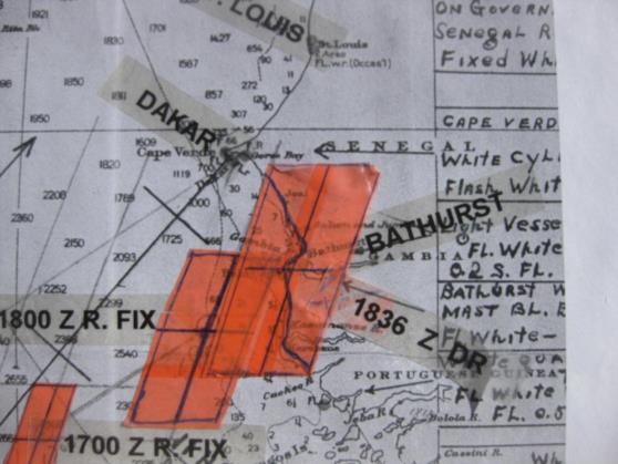
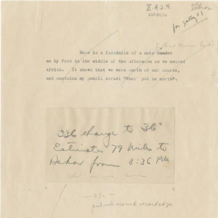
Now it gets even stranger. Earhart produced a note from Noonan that she received in flight
telling her to turn to 36̊ M at 1836 Z (3:36 p.m. Natal time). (See note 2.) This magnetic
heading would have caused the plane to fly north- northeast, parallel to the 1800 Z line, which
ran 40̊ M, with an allowance of a 4̊ wind correction angle for a light wind out of the west. But,
since this turn would not have occurred until 36 minutes later, the plane would have traveled 78
NM further to the northeast prior to making the turn. There is no notation on the chart indicating
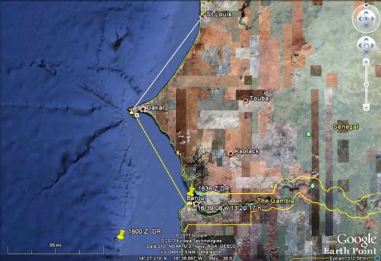
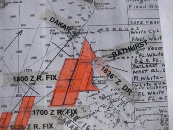
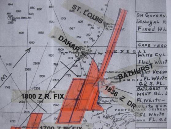
this 1836 Z DR position. I plotted it on my chart and it falls almost directly over the town of
Bathurst (now called Banjul.) The band of uncertainty at the 1836 Z DR position is a bit larger
than the 1800 Z band and they overlap. (See image 16.) But we can eliminate from this band of
uncertainty that portion that is over land since they would have seen the coastline below them.
(See image 17.) A turn from the 1836 Z position to a heading of 36̊ M would have taken them
into “deepest, darkest, Africa” and nowhere near either Dakar or St. Louis. (See image 18.) From
the 1836 Z position above Bathurst to St. Louis is 160 NM but the time remaining to landing
would have been only 51 minutes so the plane would have had to fly at 188 K to make it, so we
know the plane was not at that position at that time. At its 130 K cruising speed the plane could
only cover 110 NM in 51 minutes. From the nearest edge of the band of uncertainty it was only
80 NM so the plane could have been in the northern section at 1836 Z. But Dakar was only 95
NM from the 1836 Z position so it would have been quicker and easier for them to just follow
the coastline there and it was even closer with the plane in the northern sector.
Just flying on a heading of 36̊ M was not likely to take them directly to St. Louis and might
have gotten them lost in the jungle. To avoid this possibility, and to ensure that they found St.
Louis, all they had to do was turn to a heading of about 345̊ T (004̊ M) as soon as they saw the
coast. This heading would have worked no matter where exactly they hit the coast, after turning
at 1800 Z or at 1836 Z. This heading would have taken them across the Cape Verde peninsula to
intercept the coastline between Dakar and St. Louis and would have guaranteed that they did not
overshoot St. Louis. Earhart said that they hit the coastline between Dakar and St. Louis and I
believe her, only they hit it coming from the land side, not coming in from over the ocean. Then,
like she said, they followed the shoreline to St. Louis, as planned.
Of course the reason the Dakar story had relevance to the final disappearance is that it offered an
explanation for why they were unable to find Howland. It seemed possible, at the end, that
Earhart refused, as she had done on the approach to Dakar, to follow Noonan's advice on the
heading to follow that would have taken them the Howland.
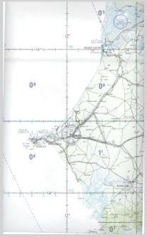
I have attached a portion of aeronautical chart ONC K-0 depicting Dakar and St. Louis which I
think will be of interest. (See chart 3.)
When I first heard the "I turned the wrong way when hitting the coast of Africa" story, I assumed
that the coast, at that point, ran in a straight line so that AE could reasonably question which side
of Dakar they were actually on. Now however, looking at this chart, it is impossible to believe
that story. The coast north of Dakar trends 040º T while south it trends 320º T, a difference of
80º, almost a right angle. All she had to do was point the plane along the shoreline and look at
her compass. If it said about 059º (allowing for 19º of west variation) she was north of Dakar and
if 339º she was south. No way to mistake this, there was no possible ambiguity. To make it even
simpler, the sun was setting in the west. If they had hit the coast north of Dakar then they should
have followed the coast to the southwest. If they had hit the coast south of Dakar then they
should have followed the coast to the northwest. Either way, if the sun was not in their eyes then
they were going the wrong way, didn’t even need a compass.
I think, for whatever reason (maybe better service available from the Air France facility,
personal contacts, etc.), they made a conscious decision to go to St. Louis and crossed the
coastline southeast of Dakar and proceeded overland to intercept the coast north of Dakar and
followed it to St. Louis. AE writes in "Last Flight"(page 119.)
"At St. Louis are the headquarters of Air France for the trans-Atlantic service, and I was grateful
for the field's excellent facilities, which were placed at my disposal."
Elgin Long thinks that they aimed directly for Dakar and that they passed west of Dakar and then
turned east and hit the coast north of there as Earhart said but there is a problem with his theory,
namely the 1800 Z LOP which showed that they had already passed the point where turning to
the heading Noonan had recommenced would have taken them to Dakar, and Noonan wanted her
to proceed even further to the northeast for another 36 minutes, 78 NM, prior to making the
turn. Most significantly, to the question of whether they accidentally missed Dakar, you can see
on Noonan’s chart that there had been a sun line that ran to Dakar on an approximate 21º T
course but this line was erased (but still visible) and the sun line was advanced to 1800 Z to run
to Saint Louis. This confirms that they deliberately hit the coast south east of Dakar and then
deliberately flew to Saint Louis. It's no coincidence that the 1800 Z sun line runs directly to Saint
Louis. and that the parallel line to Dakar had been erased. Long also fudged by stating that even
though they knew they were flying the wrong way, that Earhart knew that there were other
airports every 150 SM along the coast that she could go to. Even if this were true, they also knew
that the nearest airport to them was Dakar, it might be only ten miles to the southwest while St.
Louis could have been 100 NM ahead. He also wrongly claims that there were no airports south
of Dakar that they could have landed at if they had turned to the south and they were actually
going the wrong way. In 1934 an airport had been built at Bathurst and by 1937 it was in use for
scheduled trans-Atlantic airline flights to Rio de Janeiro. The 1836 Z position put them directly
over Bathurst or very nearby.
Ric Gillespie agrees with me that they struck the coast southeast of Dakar (but his chart work
was wrong) but he then comes up with an explanation that doesn't make sense for their failure to
simply follow the coastline northwest to Dakar. Gillespie claims that flying into the sun in hazy
conditions would have made it too difficult to follow the coastline. Gillespie is wrong because
the easiest thing to do in hazy conditions is to follow a coastline! Flying into the sun in hazy
conditions limits visibility and pilots don’t like to do it, not because it would be difficult to
follow the coastline but because of concern about bumping into another airplane. There were not
very many airplanes flying near Dakar in 1937!
Earhart’s explanation was a complete fairytale, it never happened, and it is possible that note 2
was just a fabrication to support the fairytale since it makes no navigational sense. As further
proof that any competent navigator would have planned to hit the coast to the southeast of
Dakar, the Air Force navigation manual, AFM 51-40, uses this exact flight from Natal to Dakar
as the example of how to plan such a flight. (I have attached an excerpt from this manual, see
AFM-51-40.)
We may never know the real reason that they chose to go to St. Louis but it was an obvious
decision that they had made to fly overland to St. Louis instead of following the coast to Dakar.
The bottom line is that the Dakar flight provides no help in explaining
the final disappearance.
( I have also attached a Google Earth image that makes it easy to see the relationships.)
Gl
----------------------------------------------------------------
NavList message boards and member settings: www.fer3.com/NavList
Members may optionally receive posts by email.
To cancel email delivery, send a message to NoMail[at]fer3.com
----------------------------------------------------------------
