NavList:
A Community Devoted to the Preservation and Practice of Celestial Navigation and Other Methods of Traditional Wayfinding
Re: Earhart article
From: Gary LaPook
Date: 2014 Dec 21, 22:41 -0800
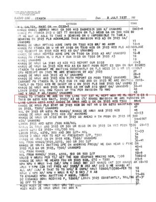
"WE ARE ON THE LINE 157 337."
From: Gary LaPook
Date: 2014 Dec 21, 22:41 -0800
"WE ARE ON THE LINE 157 337."
That was the last transmission from Amelia Earhart, recorded at 0843 ship's time (2013 Z) in the radio log of the
Coast Guard cutter Itasca.
It's all about celestial navigation.
As Earhart approached her destination of Howland island on July 2, 1937 the sun was rising on an azimuth of 067°.
157° perpendicular to 067°, a coincidence?
I think not.
Earhart's navigator, Fred Noonan, was using a standard method for finding an island destination during daylight when only a sun line was available for navigation. Plan a course to intercept the LOP that runs through the destination, take sextant shots to determine when you have intercepted that
LOP, turn and follow it to the island taking additional sextant shots to insure staying on the LOP. This method was discovered by Francis Chichester in 1931 when he flew a very small plane across the Tasman sea and had to find two very small islands along the way.
I first became interested in the Earhart mystery when TIGHAR announced in 1992 that they had found Earhart's shoe heel on the island of Nikumororo, 350 nautical miles to the south southeast of Howland. TIGHAR claimed that they had simply followed the 157° sunline LOP all the way to that island, had landed there and then died as castaways.
When I read this I knew that it was wrong.
Although the 157° LOP passed very close to Nikumororo (then known as Gardner island) we navigators know that the LOP will change as the sun moves across the sky. As the sun moves across the sky the 157° LOP ceases to exist, becoming progressively more easterly as the sun moved counterclockwise and reaching 126° (a
change of 31°) by the time that they could have been approaching Nikumororo, passing 230 nautical miles to the north east of that island.
TIGHAR has been soliciting funds for various expeditions and paying the head of the organization lots of money, $238,000 last year (according to IRS records) and his ace card is that Earhart uttered those words.
I put up a website where navigation manuals from that era can be read by anybody interested in evaluating the navigational claims
of TIGHAR for themselves, and these might be of interest to the navigators here.
See attached.
gl


