NavList:
A Community Devoted to the Preservation and Practice of Celestial Navigation and Other Methods of Traditional Wayfinding
From: Frank Reed
Date: 2024 Feb 3, 13:04 -0800
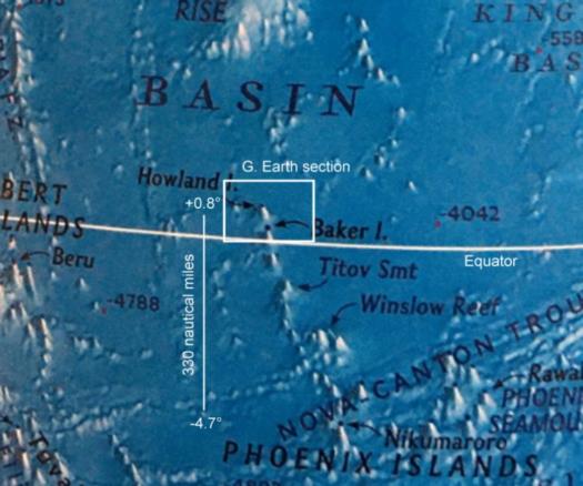
Although that National Geographic atlas was presumably printed in 2010, the artwork for the ocean floor is probably older. It's not "wrong" exactly but be aware that there's significant artistic license involved.
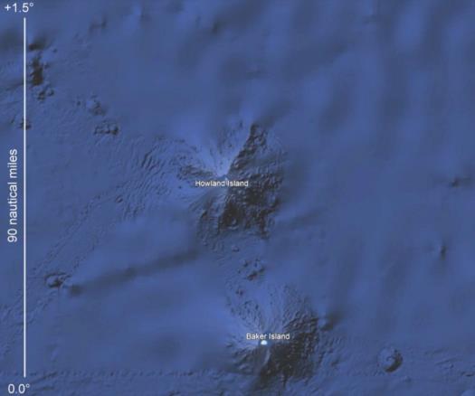
The area that you photographed in that atlas is an enormous region! I cut out a little section from the middle of your image to indicate the overall scale and also to show the principal problem with the TIGHAR Nikumaroro model. That island is over 300 nautical miles from Howland. Did they glide the whole way??! I'm also including a little section around Howland and Baker from Google Earth to show something close to the "state of the art" in ocean bathymetry in that area. This is still a large area, about 90 nautical miles north to south and about 108 n.m. east to west.
Also, in Google Earth, you can wiggle your mouse pointer around and read off the estimated ocean depth at various locations. The abyssal plain around here is about 17,000 feet down, and the dropoff from sea level at the two islands is at a relatively constant rate of about 0.25 (14° inclination). That implies that if you travel 10,000 feet from shore, you'll end up in water that's about 2500 feet deep. Go 20,000 feet... the depth is around 5000 feet. That rate is far from perfect. There's a lot of small-scale detail to the bathymetry which has been well-mapped close to shore on the slopes of the seamounts. The apparent fuzziness of the surrounding regions reflects the fact there are no significant deepwater surveys in those areas. Many regions in the Central Pacific have had their bathymetry mapped only by estimation based on sea surface features as measured by orbiting satellites [a mountain on the ocean floor has its own gravitational field which draws in water above it creating an almost imperceptible "hill" on the ocean's surface which can be detected by satellite].
Suppose you decide that Earhart's Electra is somewhere in the region of this Google Earth image that I'm attaching here. It's a region or 90x108 or 9720 square nautical miles. Suppose you can survey ten square miles per day (which is optimistic). That implies two years and eight months to survey the whole region. That's expensive! But then again, let's be clear: that airplane is down there... somewhere! Unless we believe in conspiracy theories or exotic solutions, it's as Bob Ballard said, "This plane exists... It’s not the Loch Ness monster, and it’s going to be found." Well-said. He was quoted in the NYTimes after returning from the search in the vicinity of Nikumaroro. Basically he had called the bluff of the TIGHAR folks and agreed to search exactly the area where they contended Earhart's plane would be found. They found no plane. But that only rules out their specific Nikumaroro model. It does not change reality: "this plane exists".
Frank Reed


