NavList:
A Community Devoted to the Preservation and Practice of Celestial Navigation and Other Methods of Traditional Wayfinding
From: Sean C
Date: 2021 Oct 8, 23:22 -0700
Well, I started to analyze the two tables ... but then the Admiral decided the new ceiling fan for the dining room had to be installed immediately. So, after doing that, I began to dig in to the tables.
I knew that both tables were going to produce errors in latitude to some degree, so I decided to calculate the magnitude of those errors for each table and compare them. Here's the steps I took:
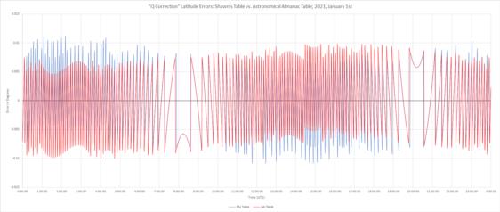
- Calculate the altitude of Polaris using my spreadsheet for each minute of 2021, January 1st at a longitutde of 0° and a latitude of say ... 45° N
- Manually enter both tables into Excel
- Use a formula to look up the correction for the LHA of Aries at each minute from both tables and apply that to the calculated altitude of Polaris
- Subtract the resulting latitude from 45° and graph the data
After looking at the first chart (Jan. 1st, attached below), it seemed to me that the algorithm used by both is very similar ... but the rules for defining the cutoff from one correction to the next must be different. In any case, I think you will see that the errors in either case are trivial when it comes to the precision needed for the task.
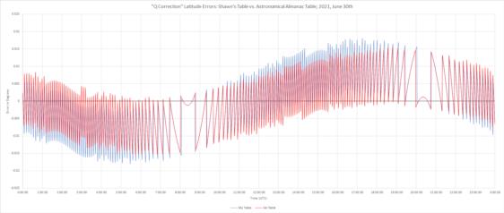
To be honest, I can't recall if I calculated my table for January 1st or June 30th. I might have done the latter in an effort to make the table more accurate over the entirety of 2021 ... maybe? So I decided to see what the difference was on that date, too. That chart is also attached below.
I'd be interested to hear everyone else's thoughts.
Regards,
Sean C.


