NavList:
A Community Devoted to the Preservation and Practice of Celestial Navigation and Other Methods of Traditional Wayfinding
Re: First Noon Sight: Astra IIIb
From: Peter Hakel
Date: 2014 Apr 11, 18:14 -0700
From: Sean C <yhshuh@gmail.com>
To: pmh099@yahoo.com
Sent: Friday, April 11, 2014 4:36 PM
Subject: [NavList] Re: First Noon Sight: Astra IIIb
----------------------------------------------------------------
NavList message boards and member settings: www.fer3.com/NavList
Members may optionally receive posts by email.
To cancel email delivery, send a message to NoMail[at]fer3.com
----------------------------------------------------------------
From: Peter Hakel
Date: 2014 Apr 11, 18:14 -0700
Sean,
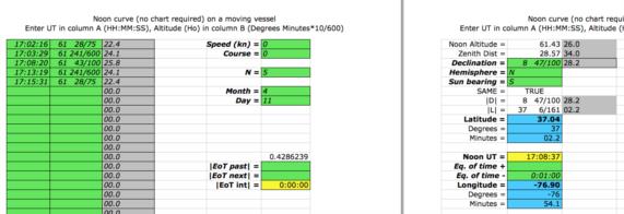
Thanks for posting your data; I get a latitude result:
N 37° 02.2’
that is very close to yours and Frank’s. My longitude result is 20 miles west of the AP.
Peter Hakel
Thanks for posting your data; I get a latitude result:
N 37° 02.2’
that is very close to yours and Frank’s. My longitude result is 20 miles west of the AP.
Peter Hakel
From: Sean C <yhshuh@gmail.com>
To: pmh099@yahoo.com
Sent: Friday, April 11, 2014 4:36 PM
Subject: [NavList] Re: First Noon Sight: Astra IIIb
Frank, you wrote:
"That's not Local Mean Time."
Ah, yes. I have been guilty of this before. I need to try and remember not to do that. :)
And you asked:
"...how did you decide what sights were worth considering?"
Well, as I mentioned, I was having a little trouble before moving one of the horizon
shades into place. I believe this resulted in some very large errors in my pre-noon sights. I think this may also account for my rather large error in longitude, as Greg discovered. For example, just after the sight at 13:03:29 (61°11.8'), I had a sight at 13:05:36 of 61°10.0'. Now, I already knew local noon was at 13:07, so the Sun couldn't possibly be decreasing in altitude yet. But which one is right? I kept taking sights until the Sun was definitely descending and by that time the altitude was getting close to the sight at 13:03. I then pre-set the sextant to that altitude and waited until the limb was on the horizon and recorded the time. Same thing for the last altitude I gave. For my own calculations, I split the difference between both sets and used the average. The result was in error by about 20nm west.. For grins, I used the exact time of the highest recorded altitude, 13:08:20, and got an error of about 15nm west.
Hope that made sense.
Regards,
Sean C.
Sean C.
----------------------------------------------------------------
NavList message boards and member settings: www.fer3.com/NavList
Members may optionally receive posts by email.
To cancel email delivery, send a message to NoMail[at]fer3.com
----------------------------------------------------------------
: http://fer3.com/arc/m2.aspx?i=127535


