NavList:
A Community Devoted to the Preservation and Practice of Celestial Navigation and Other Methods of Traditional Wayfinding
Re: Frank Worsley, Master Navigator
From: George Huxtable
Date: 2009 Feb 21, 10:36 -0000
From: George Huxtable
Date: 2009 Feb 21, 10:36 -0000
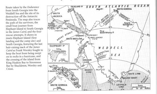
With apologies to those who have only a slow download, I attach some mapping
that deals with the James Caird's passage from Elephant Island to South
Georgia.

Brad had asked- "What I would like to know is if he just sailed down a
latitude line or went great circle."

Neither, really.

The point about latitude sailing was that it worked even if you had no
longitudes, but Worsley still had a chronometer, which had remained pretty
trustworthy.

On a passage of 800 miles, there's little difference between rhumb-line
sailing and great-circle sailing.

You will see quite a lot of disagreement between those maps, attached, which
will be no surprise. Worsley acknowledged how crude his navigation was, and
the details of the wild approach to South Georgia were no more than sketchy.
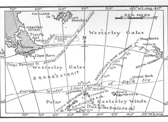
The most "authentic" map was indeed Worsley's own, from "Shackleton's Boat
Jorney", which I was quite wrong to describe, in a previous posting, as
"having no maps". It has just this one map, of considerable value.

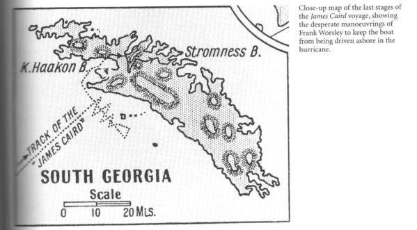
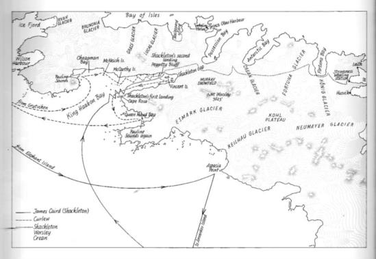
The other maps are more recent interpretations of the passage, by John
Thomson, in "Shackleton's Captain" (1999), and in "Antarctic Oasis", by Tim
and Pauline Carr (1998). But they can only have had Worsley's log, and map,
to work from. However, the Carrs have also visited the bay of the landfall,
their own track being shown as well, so they have real "local knowledge".

Worsley's map shows an initial course shaping more Northwards, intending to
round the NW end of South Georgia toward the whaling stations, but then,
after the change of plan, heading directly for the SW-facing coast, which is
quite barren of any occupants.

I hope that Brad, when he has investigated his copy of Worsley's log, will
kindly transcribe for us some of its more interesting bits, with some
calculations, if they remain legible. Worsley noted that at the time he had
found his own figurings, written with frostbitten fingers in mittens,
difficult to read.

In my last posting, I mentioned the "mountain descent into Grytviken", but
got that wrong. The whaling station that was first reached was at Husvik;
Grytviken being quite a way further East.

George.

contact George Huxtable, at  george@hux.me.uk
or at +44 1865 820222 (from UK, 01865 820222)
or at 1 Sandy Lane, Southmoor, Abingdon, Oxon OX13 5HX, UK.

--~--~---------~--~----~------------~-------~--~----~
Navigation List archive: www.fer3.com/arc
To post, email NavList@fer3.com
To , email NavList-@fer3.com
-~----------~----~----~----~------~----~------~--~---


