NavList:
A Community Devoted to the Preservation and Practice of Celestial Navigation and Other Methods of Traditional Wayfinding
From: Frank Reed
Date: 2014 Dec 2, 10:32 -0800
A bit off-topic...
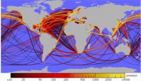
There is a little map that has been making the rounds within the past few days under the title "A new infographic uses GPS to map out the world's shipping routes over a year's time" (see below; and link to source). I have a feeling that this is being over-sold with fashionable language. For example, it's described as an "infographic" not a "map," and it "uses GPS" --as if that would make any difference at this scale. People have been successfully mapping global shipping routes based on departure and arrival data for a century or two. Whoever constructed this chart has used great circle arcs to connect ports and avoid land. Modern ships don't sail on perfect great circle arcs, at least with nothing like the mathematical perfection displayed on this map so those arcs are "art", not data.
Maps like this are fun and informative representations of generalized shipping routes, of course, but there's no need to claim it's done with "GPS". Certainly archived AIS data (ultimately GPS in origin) from sources like MarineTraffic.com makes this sort of map easier to construct, but otherwise it's not much different from similar "infographics" prepared a century ago.
Frank Reed
Conanicut Island USA


