Welcome to the NavList Message Boards.

NavList:

A Community Devoted to the Preservation and Practice of Celestial Navigation and Other Methods of Traditional Wayfinding

Compose Your Message

Message:αβγ
Message:abc
Add Images & Files
    Name or NavList Code:
    Email:
       
    Reply
    Re: Gnomonic North Atlantic
    From: Peter Hakel
    Date: 2023 Jun 2, 21:28 -0700

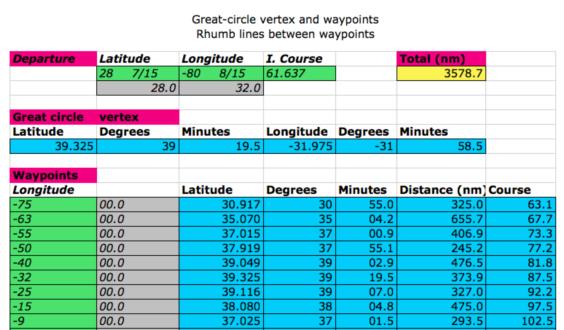
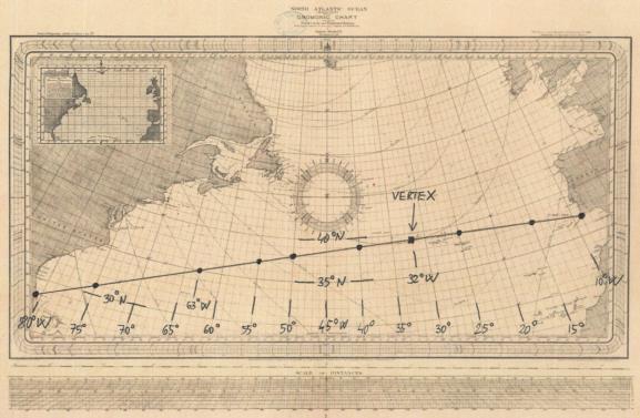
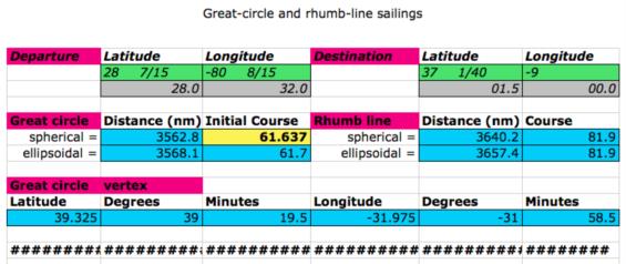
    The recently posted gnomonic charts of North Atlantic Ocean provided me with an excuse to do a fun demo/exercise. I drew a line between Cape Canaveral (28° 28’ N, 80° 32’ W) and Cape St.Vincent (37° 01.5’ N, 9° 00’ W). I then calculated selected points along the great circle that can be easily viewed on the chart:

    75° W, 31° N
    63° W, 35° N
    55° W, 37° N
    50° W, 38° N
    40° W, 39° N
    32° W, 39° 20’ N (great-circle vertex: maximum latitude)
    25° W, 39° N
    15° W, 38° N
     9° W, 37° N (destination)


    Peter Hakel
    File:


    File:


    File:


    Reply
    Browse Files

    Drop Files

    NavList

    What is NavList?

    Get a NavList ID Code

    Name:
    (please, no nicknames or handles)
    Email:
    Do you want to receive all group messages by email?
    Yes No

    A NavList ID Code guarantees your identity in NavList posts and allows faster posting of messages.

    Retrieve a NavList ID Code

    Enter the email address associated with your NavList messages. Your NavList code will be emailed to you immediately.
    Email:

    Email Settings

    NavList ID Code:

    Custom Index

    Subject:
    Author:
    Start date: (yyyymm dd)
    End date: (yyyymm dd)

    Visit this site
    Visit this site
    Visit this site
    Visit this site
    Visit this site
    Visit this site