NavList:
A Community Devoted to the Preservation and Practice of Celestial Navigation and Other Methods of Traditional Wayfinding
Re: Graphically solving haversine calculation
From: Peter Hakel
Date: 2015 Nov 14, 01:48 +0000
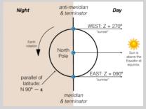
For me it was helpful to visualize this arrangement as a helmet (Earth) with a central stripe (terminator), and a thin visor. At equinox the Sun is placed above one of the visor’s pivot points. The stripe is also your meridian and the visor’s arc points toward the Sun at all times, indicating Sun's azimuth. Your location is the intersection of the visor and the stripe. No matter how you tilt the visor, it remains perpendicular to the stripe. This is akin to observing the sunrise/sunset at equinox, in which case we have this perpendicularity at any latitude. Whether this right angle indicates azimuth of “East” or “West” depends on where the “North Pole” of that helmet is located along the stripe.
Peter Hakel
From: Jaap vd Heide <NoReply_JaapvdHeide@navlist.net>
To: pmh099@yahoo.com
Sent: Friday, November 13, 2015 2:36 PM
Subject: [NavList] Re: Graphically solving haversine calculation
From: Peter Hakel
Date: 2015 Nov 14, 01:48 +0000
In the attached cartoon (looking down on the Earth along its axis) the blue dots represent three locations (separated by, say, 1 meter -> epsilon) that are indistinguishable in a practical sense. As an academic exercise however, they are different from one another, as is sometimes the case when mathematical singularities (in this case, the North Pole) are involved. Azimuth remains well defined as you approach the Pole, exactly at the Pole it suddenly becomes meaningless, and then just past the Pole it jumps back into existence - with a discontinuous change in its value. The azimuth formula will run into numerical difficulties once you get “close enough” to the singularity, and it fails when you reach the Pole.
For me it was helpful to visualize this arrangement as a helmet (Earth) with a central stripe (terminator), and a thin visor. At equinox the Sun is placed above one of the visor’s pivot points. The stripe is also your meridian and the visor’s arc points toward the Sun at all times, indicating Sun's azimuth. Your location is the intersection of the visor and the stripe. No matter how you tilt the visor, it remains perpendicular to the stripe. This is akin to observing the sunrise/sunset at equinox, in which case we have this perpendicularity at any latitude. Whether this right angle indicates azimuth of “East” or “West” depends on where the “North Pole” of that helmet is located along the stripe.
Peter Hakel
From: Jaap vd Heide <NoReply_JaapvdHeide@navlist.net>
To: pmh099@yahoo.com
Sent: Friday, November 13, 2015 2:36 PM
Subject: [NavList] Re: Graphically solving haversine calculation
IMHO the poles are interesting all year round.
With P being one of the poles, AP the (assumed) position and GP the geographical position of the sun, when P and AP coincide the navigational triangle is reduced to a line between two points (or better an arc being part of the meridian running through GP) and there no longer is a LHA nor an Azimuth. Whereever you look is to the other pole, so either South or North.
Near the poles, I believe the text is correct, although it will be very hard to either measure or calculate by use of the spherical law of cosines.
I would say this is a quirk in reality, rather than a quirk in the text.


