NavList:
A Community Devoted to the Preservation and Practice of Celestial Navigation and Other Methods of Traditional Wayfinding
From: David C
Date: 2017 Dec 2, 13:55 -0800
One of he dangers of trying to be smart is that it easy to make a mistake. I did just that.
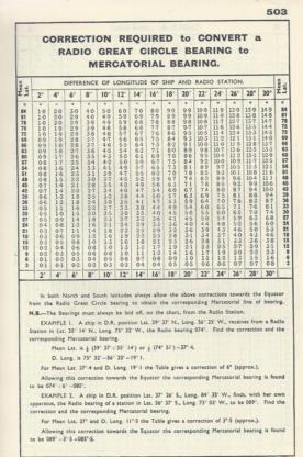
The radio Bearing table in Norie told me that for a mean latitude near zero the half-convergency is < 1°. That means, I reasoned, that the Boston - Wellington GC is very close to the rumb line. Hence, my reasoning contined, if I draw a straight line on a mercator chart I will have the GC. What I overlooked is that the maximum dlong in the table is 30° whereas the actual dlong is much greater.
On the plus side this thread has created some discussion and so I will sit back, lurk, and enjoy reading the comments........
And yes, as Frank has pointed out, the map was published in an era when "the thin red line" meant something different to what it probably does today.


