NavList:
A Community Devoted to the Preservation and Practice of Celestial Navigation and Other Methods of Traditional Wayfinding
From: Frank Reed
Date: 2017 Dec 3, 08:13 -0800
Bob,
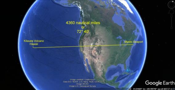
You can use Google Earth in this fashion. Rotate the view until the start and end points and the visual center of the globe are on a straight line. That's the great circle track.
Last Spring, quite by chance, I had an evening class for which the Sun was straight up over the "big island" of Hawaii right at the start of the first session. This was convenient since that's when I go over the basic principle of celestial navigation. It was nice to be able to take folks outside, look at the Sun low in our sky towards the west and put the pieces of zenith distance and distance on the ground together so visually and with a nice familiar, tropical target like Hawaii beneath the Sun. I'm attaching the graphic that I used to illustrate this. Notice how the center of the circle of the projected globe and the start and end points are all aligned on a straight line. Again, that's guaranteed to be the great circle track. This was done by simple, manual "rolling" in Google Earth.
Say... come to think of it, whenever I have this discussion about the place where the Sun is straight up, it does always seem to be a nice "tropical" target. What a coincidence! Heh. Or maybe not. ;)
Frank Reed


