NavList:
A Community Devoted to the Preservation and Practice of Celestial Navigation and Other Methods of Traditional Wayfinding
From: Frank Reed
Date: 2014 Dec 12, 12:25 -0800
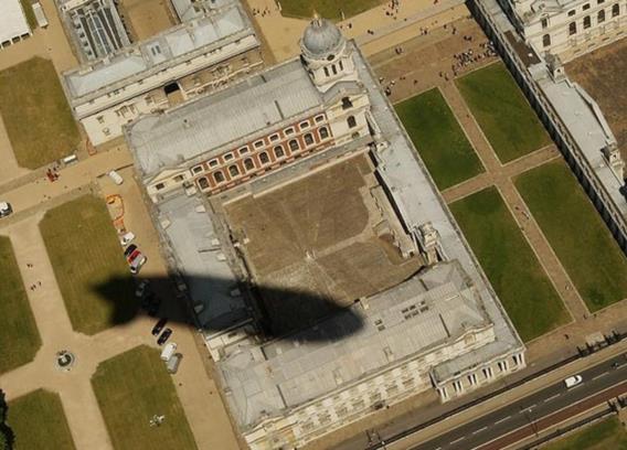
Yesterday I posted this image of the shadow of a "zeppelin" over London. I could not identify the buildings at the time, but as I looked at the photo again this afternoon, it dawned on me that the setting looked familiar. I walked by that fountain just two years ago! The airship is flying over Greenwich. These buildings are the Old Royal Naval College, currently occupied by the University of Greenwich. I would say that at the time of the photograph the airship was passing almost directly over the main hall of the National Maritime Museum. A nice coincidence for a NavList message. The longitude of the airship was less than a minute of arc west of the prime meridian... Based on the shadow locations and assuming the date is July 10, I estimate that it's between 10:45 and 11:00 am.
So has anyone else determined the airship's altitude yet? I get roughly 800 feet for the slant height which would imply about 700 feet for the vertical altitude. It all depends on the angular diameter of the Sun which is what determines the width of the "fuzzy edge" or penumbra of the airship's shadow...
Frank Reed
Conanicut Island USA


