Welcome to the NavList Message Boards.

NavList:

A Community Devoted to the Preservation and Practice of Celestial Navigation and Other Methods of Traditional Wayfinding

Compose Your Message

Message:αβγ
Message:abc
Add Images & Files
    Name or NavList Code:
    Email:
       
    Reply
    Re: Historical Tide Data
    From: Frank Reed
    Date: 2015 Apr 16, 12:36 -0700

    Antoine,

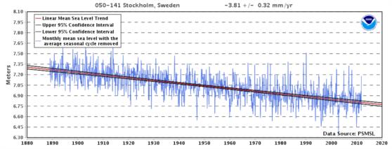
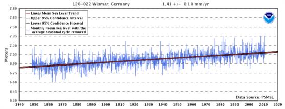
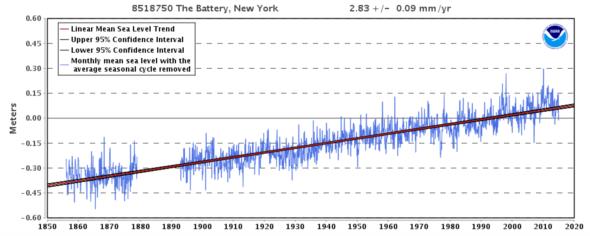
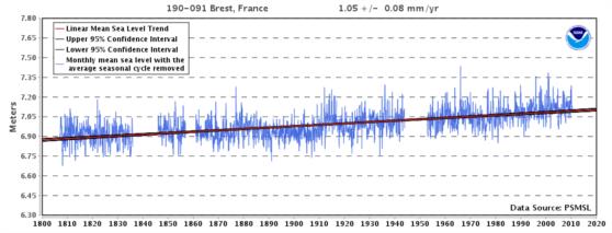
    Yes, the same NOAA sea level trend site also has graphs for many global (non-US) locations including Brest. Below (attached) is the sea level trend for Brest from about 1807 to about 2010. By the way, these data reflect "relative sea level" rather than global sea level, which explains why sea level at Brest is rising more slowly than in New York. I'm also attaching graphics for Stockholm, Sweden (where relative sea level is falling as that region conntinues its re-emergence from the weight of the ice cap of the last glaciation) and also for Wismar, Germany which has a long data set, though not as long as Brest, which I believe is the global record-holder.

    Frank Reed
    Conanicut Island USA (listen to the peepers and see the surf... turn up volume!)


    File:


    File:


    File:


    File:


    Reply
    Browse Files

    Drop Files

    NavList

    What is NavList?

    Get a NavList ID Code

    Name:
    (please, no nicknames or handles)
    Email:
    Do you want to receive all group messages by email?
    Yes No

    A NavList ID Code guarantees your identity in NavList posts and allows faster posting of messages.

    Retrieve a NavList ID Code

    Enter the email address associated with your NavList messages. Your NavList code will be emailed to you immediately.
    Email:

    Email Settings

    NavList ID Code:

    Custom Index

    Subject:
    Author:
    Start date: (yyyymm dd)
    End date: (yyyymm dd)

    Visit this site
    Visit this site
    Visit this site
    Visit this site
    Visit this site
    Visit this site