Welcome to the NavList Message Boards.

NavList:

A Community Devoted to the Preservation and Practice of Celestial Navigation and Other Methods of Traditional Wayfinding

Compose Your Message

Message:αβγ
Message:abc
Add Images & Files
    Name or NavList Code:
    Email:
       
    Reply
    Re: Historical charts and mapping
    From: Robin Stuart
    Date: 2016 Aug 23, 10:18 -0700

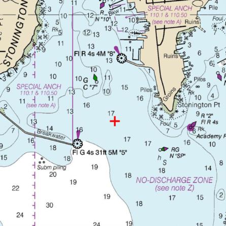
    I thought it might be instructive to plot the 1847 position given for the Stonington Lighthouse (41°19'36"N, 71°54'36"W) on the modern chart. The position is marked by the red cross in the attachment. The difference is in the wrong direction to be attributable to the offset between the Greenwich and WGS84 zero meridians https://NavList.net/imgx/greenwich-longitude-offset.pdf

    Robin Stuart


    File:


    File:


    Reply
    Browse Files

    Drop Files

    NavList

    What is NavList?

    Get a NavList ID Code

    Name:
    (please, no nicknames or handles)
    Email:
    Do you want to receive all group messages by email?
    Yes No

    A NavList ID Code guarantees your identity in NavList posts and allows faster posting of messages.

    Retrieve a NavList ID Code

    Enter the email address associated with your NavList messages. Your NavList code will be emailed to you immediately.
    Email:

    Email Settings

    NavList ID Code:

    Custom Index

    Subject:
    Author:
    Start date: (yyyymm dd)
    End date: (yyyymm dd)

    Visit this site
    Visit this site
    Visit this site
    Visit this site
    Visit this site
    Visit this site