NavList:
A Community Devoted to the Preservation and Practice of Celestial Navigation and Other Methods of Traditional Wayfinding
From: Andrés Ruiz
Date: 2009 Sep 24, 16:26 +0200
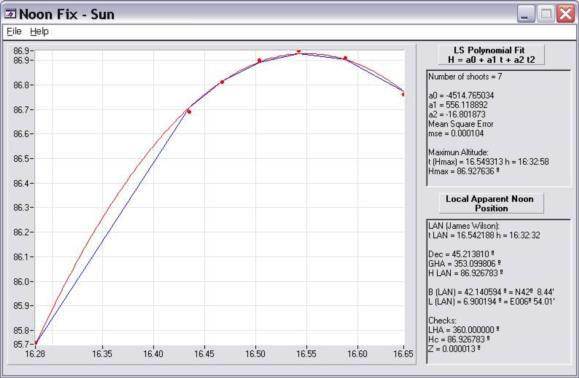
For the 7 shoots:
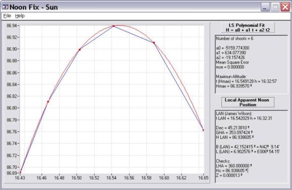
Without #7:
Note the error in position
due to 1s of error in the time of transit.
Andrés Ruiz
Navigational Algorithms
http://sites.google.com/site/navigationalalgorithms/
De:
navlist@fer3.com [mailto:navlist@fer3.com] En nombre de P H
Enviado el: domingo, 20 de
septiembre de 2009 23:30
Para: navlist@fer3.com
Asunto: [NavList 9827] Re: IN
HONOR OF JEREMY TWO STARS FULL LAN's : ONE UPPER and ONE LOWER CULMINATION
Hello Antoine,
For this example I get:
UT LAN: 16:32:30
Vessel coordinates at 16:30:00 UT
Latitude:
N 42 deg 08.4'
Longitude: E 6 deg 53.7'
This location is in the Mediterranean, west of Corsica and southeast of
Marseille.
I should point out that I included only data #1 through #6 in the calculation,
since I was not sure how to interpret #7.
Peter Hakel
*******
DENEB
This first one occurred on Nov 16, 1979 on one of the then 2 French Navy
Aircraft Carriers ( CLEMENCEAU or FOCH ? ) one evening when I was not flying my
trusty F8E(FN) CRUSADER. It was almost by accident, as I noticed a few minutes
earlier that Deneb would be full north of our vessel and I attempted to shoot
it during the few minutes available.
Date 16 Nov 1979
Course 040° , Speed 22.0 Kts , Sea Current towards true direction of 050° at
speed 0.5 kt
Height of Eye
DENEB is at the NORTH of the Vessel at its Upper Culmination
The following data were then published in the French "Ephemerides
Nautiques"
BODY : DENEB
Verse Ascension : 049°49.0'
Declination : N49°49'0
Greenwhich Hour Angle of Aries at 16h00m00.0s was 295°07.9'
All Heights already corrected for Instrument and Index Error. All times in UT
#1 - 16h26m06.0s 86°50'8
#2 - 16h28m02.0s 86°58'0
#3 - 16h30m12.0s 87°03'3
#4 - 16h32m31.0s 87°05'7
#5 - 16h35m18.0s 87°04'0
#6 - 16h38m43.0s 86°55'1
blank line on purpose here
#7 - 16h17m02.0s 85°54'3
Give DENEB Transit time, i.e. DENEB being true North of moving vessel and
vessel's position at time UT 16h30m00.0s . Any indication on FIX confidence is
welcome.
*******
--~--~---------~--~----~------------~-------~--~----~
NavList message boards: www.fer3.com/arc
Or post by email to: NavList@fer3.com
To , email NavList-@fer3.com
-~----------~----~----~----~------~----~------~--~---


