NavList:
A Community Devoted to the Preservation and Practice of Celestial Navigation and Other Methods of Traditional Wayfinding
From: Frank Reed
Date: 2018 Feb 7, 13:56 -0800
One of the fundamental limiting factors in standard celestial navigation is uncertainty of the sea horizon. There are height of eye issues, but even more important is variable refraction which lifts the horizon up from its geometric position and also allows us to see beyond the geometric horizon. Often the horizon looks choppy or even appears as if it's broken up into bits of confetti. I have been thinking about these issues for rather a long time... Last night I found some photos I took nine years ago in an unusual circumstance.
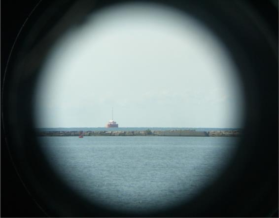
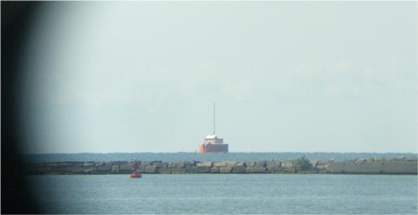
In August 2009, I was visiting th WW2-era fleet submarine "USS Cod" on the shore of Lake Erie in downtown Cleveland, Ohio. It's a fine submarine in excellent condition. They also have a periscope set up on-shore, and visitors can look through it and see the breakwater and the lake horizon beyond. The day I was there it was pointed at the water-intake "crib" about three and a half miles out in the lake. I took a few photos, and you can clearly see the refraction-distorted horizon. The waviness and "choppiness" visible here is not waves on the water surface. It's a refraction-driven mirage-like phenomenon. In the photo we can determine the scale of this "waviness" since the height of the antenna on the crib is known and we can determine the distance to the stucture from the location of the submarine.
The antenna is reported to reach 165 feet above the lake surface. The crib is located at 41°32.9' N, 81°45.0' W. The submarine memorial is at 41°30.6' N, 81°41.5' W. The difference in latitude is 2.3' and the difference is longitude is 3.5'. In this latitude, the conversion factor from longitude minutes to miles (=cos(lat)) is just about 0.75 so the distance E/W is 2.625 miles. The distance N/S is identical to the difference in latitude: 2.3 miles. Then using simple Pythagoras to get the distance, that's 3.5 nautical miles or 21300 feet nearly. The ratio of height to distance is 165/21300. To convert that angle to minutes of arc we multiply by 3438 (anybody digging out a sine or a tangent here, you are doing it wrong!). The result is 27 minutes of arc from the lake surface to the top of the antenna. Note that the apparent horizon seems to obscure the lowest edge of the crib structure but it's not significant. Maybe subtract a minute of arc for that. Then looking at the image here (crib2) it's about 148 pixels from the lake surface to the top of the tower so that gives a scale of about 5.7 pixels per minute of arc. Looking along the horizon, the typical "wobble" is about 5 pixels so roughly 0.8' of arc. That's a lot of noise! And this is why celestial navigation reached its maximum accuracy by the early 19th century. Yes, we can make better sextants, and we can measure angles five or ten times better (for example, shooting lunars, which do not depend on the horizon), but the intrinsic uncertainty in the horizon is always present, and there's no way to know how large it really is.
I noted above that the lowest part of the crib structure seems to be obscured by the apparent horizon. This is also a hint at anomalous refraction since it shouldn't be obscured. The optical head of the periscope here was at least 25 feet above the lake level. That implies that the visible horizon should be about six miles away (take square root of height of eye in feet and "add a tip" --15 to 20%). But we know the crib is only 3.5 miles away. The structure should appear slightly in front of the lake horizon, not sligtly beyond it. The difference here is caused by anomalous refraction. In celestial navigation terms, this would affect the actual dip by about a half a minute of arc or so. Again, variable, anomalous refraction of the horizon places the biggest restraint on the accuracy of standard celestial navigation. It's "about a mile" and usually no better.
Frank Reed


