NavList:
A Community Devoted to the Preservation and Practice of Celestial Navigation and Other Methods of Traditional Wayfinding


From: Frank Reed
Date: 2026 Nov 10, 10:22 -0800
David Pike,
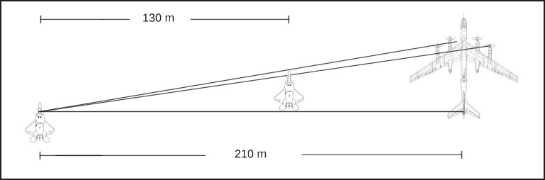
You suggested using a 'tangent half angle' relationship. I think in this case, we are actually able to use a direct 'tangent' relationship because we are looking "straight" along the tails of the two aircraft. Especially on the F-22, we can see that the tail surfaces are almost perfectly aligned from the wingman/camera point of view. And then assuming we're all flying in the same direction, which is a "given" for this sort of armed "courtesy escort", we can draw a simple right triangle with the right angle at the tail of either aircraft in the photo. So that's nice!
You asked for my estimate of a time of day... I think it has to be close to the time of true horizon sunset (Sun zenith distance 90°) because we can see shadows of the Bear's big propellers on the fuselage, more or less aligned. The Sun is probably still several degrees high as seen from that high aircraft altitude (dip at 40,000 feet about 3°20'). We can also see that the shadows are projected forward on the fuselage, which implies that the Sun is over the camera's right shoulder. Combined with the phase of the Moon and the approximate location, these imply sunset, near maybe 0200 UT on 23 Nov 2007. The local date would be 22 Nov. The previous day around the same time might work, too (22 Nov UT date, 21 Nov local date). I don't think we can be more specific than this on the time because the interception occurred somewhere in the huge area covered by Elmendorf Air Force Base (near Anchorage AK), and given also the high latitude up there, the timing changes quickly from east to west.
Frank Reed
PS: I didn't mention in my previous post that the diagram is not quite scaled correctly. After I put it together, I thought "I should fix that". Then I came to my senses. :) Also, I should note that the schematic images of the two aircraft are borrowed from the wikipedia articles on each. The original vector "svg" for the Tu-95 Bear is impressive --highly detailed.