NavList:
A Community Devoted to the Preservation and Practice of Celestial Navigation and Other Methods of Traditional Wayfinding
Re: Howland Island landfall
From: Gary LaPook
Date: 2017 Dec 22, 09:32 +0000
From: David C <NoReply_DavidC@navlist.net>
To: garylapook@pacbell.net
Sent: Wednesday, December 20, 2017 9:10 PM
Subject: [NavList] Howland Island landfall
Attached File:


From: Gary LaPook
Date: 2017 Dec 22, 09:32 +0000
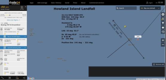
Your hc is wrong. I just worked it on my calculator and got 49-07 which is what the US Naval Observatory says. Also, how do you convert a Z of S53W to a Zn of 231?
 Celestial Navigation Data for 2017 Dec 21 at  2:00:00 UT

                 For Assumed Position:  Latitude    N   0 48.0
                                        Longitude   W 176 38.0

                        Almanac Data                |    Altitude Corrections
 Object       GHA        Dec         Hc       Zn    |   Refr   SD    PA    Sum
              o   '      o   '      o   '       o   |     '     '     '     '
 SUN        210 30.3   S23 26.0   +49 07.7   231.4  |   -0.9  16.3   0.1  15.5
From: David C <NoReply_DavidC@navlist.net>
To: garylapook@pacbell.net
Sent: Wednesday, December 20, 2017 9:10 PM
Subject: [NavList] Howland Island landfall
I hope that one of the navigator on today's flight JST2 from HNL to Howland Island was ready with his sextant at 0200 UTC. Flight planning was near perfect. The sun was almost dead ahead. The aircraft is about 40 nm from the 321 - 141 position line - say about five minutes flying time. In five minutes the position line will barely change (to 323 - 143) and the change in Hc is very small.
The navigater must be a risk taker as the offset is very small.
The only worry is the second (unidentified) aircraft. If that is also en-route to Howland Island I hope that the captains of each plane are following the Quadrantal rules.
PS Tomorow is the solstice.
Attached File:


