NavList:
A Community Devoted to the Preservation and Practice of Celestial Navigation and Other Methods of Traditional Wayfinding
Re: Hughes explanation of Chichester's navigation.
From: Gary LaPook
Date: 2014 Dec 5, 14:25 -0800
From: David Pike <NoReply_DavidPike@fer3.com>
To: garylapook@pacbell.net
Sent: Friday, December 5, 2014 1:21 AM
Subject: [NavList] Re: Hughes explanation of Chichester's navigation.
From: Gary LaPook
Date: 2014 Dec 5, 14:25 -0800
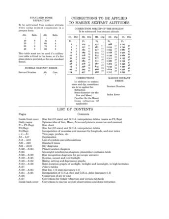
Attached is the dip table from the 2014 Air Almanac and it appears that it just uses the standard formula for dip, Dip = 0.97' (ht of eye in feet)^ -2.
The Nories table uses the same formula except the constant used is 0.98' for all the entries up to 10,000 feet. This is the same as the dip table in HO 208. From reading the discussion of dip in HO9 it appears that the refraction in the lowest layers of the air are more significant than at altitude so the tables apparently ignore the height of the plane.
gl
From: David Pike <NoReply_DavidPike@fer3.com>
To: garylapook@pacbell.net
Sent: Friday, December 5, 2014 1:21 AM
Subject: [NavList] Re: Hughes explanation of Chichester's navigation.
Dip of the Sea Horizon. Well doesn’t it make you want to spit? You look all night on the internet for a set of dip tables which go up to aircraft heights, and then you find one in front of you. Nories Tables has a set going up to 10,000ft around p149. Interestingly, it’s only one page deep, because whilst he gives you dip for every foot of height up to 100ft, he
only needs to give it every 500ft by the time you get to 10,000ft.


