NavList:
A Community Devoted to the Preservation and Practice of Celestial Navigation and Other Methods of Traditional Wayfinding
From: Frank Reed
Date: 2024 Feb 14, 13:50 -0800
Jim.
That's great. While a solar eclipse is not a lunar, it was a close-equivalent before navigators got the lunar skill. And notice that it's a singular observation. Cook did the whole grid --the great multi-sided polygon of Newfoundland-- by local surveying observations. Then with one eclipse, that network of points could be tied to the global longitude network. And rather than depending on an as yet relatively inaccurate model of the Moon's motion, the "anchoring" was done by comparison with observations of the same eclipse in the UK at Oxford.
The article from the Transactions of the Royal Society seems to have some typos. At first the article claims that the eclipse started at 0h 4m 48s local time. But later in the block showing the calculations, it's clear that the time was 0h 46m 48s. So a single digit, a "6", was dropped in the earlier description. That makes a big difference. From the same block of numbers, the eclipse ended at 3h 39m 14s local time.
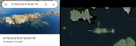
We can analyze this eclipse using modern tools. We go to tiny "Eclipse Island" off the coast of southern Newfoundland (conveniently, it's right next to my island... see attached chart). Assuming this is the island where Cook and his team observed, and I think that can be safely assumed (that it has been correctly identified), then we can set up a modern astronomical simulation tool to show us the eclipse. If we do this in Stellarium, we find that the eclipse started there at 16:42:33 UT on 5 August 1766 and ended at 19:34:55 UT. Of course nobody kept time by GMT (or UT equivalent) in 1766, so that's not directly useful. They kept local Sun time. And you can read that out in Stellarium, but it may not be entirely obvious. Local Sun time is merely the Sun's HA or "hour angle", and you can select HA as one of the listed data for each celestial object. HA is just the difference in longitude between the Sun (subSun point) and the observer. And that's the time that a sundial reads. That's local apparent time. From Stellarium the eclipse began at Eclipse Island at 0h 46m 35s, which is 13 seconds earlier than the historical reported time. From Stellarium the eclipse ended at Eclipse Island at 3h 38m 55s, which is 19 seconds earlier than the reported time. These are good, consistent observations.
The article then quickly covers the comparison with the observations made in Oxford. The result implies an excellent longitude. Of course there is some luck involved! And that's an important question: how much of the excellent resulting longitude is just good luck?
Frank Reed
[Note from FER: I corrected a math error above: 19 seconds earlier originally said 41 seconds later. I was rushing this afternoon. That's what happens!]


