NavList:
A Community Devoted to the Preservation and Practice of Celestial Navigation and Other Methods of Traditional Wayfinding
From: Jim Wyse
Date: 2024 Feb 8, 07:25 -0800
"So start talking, y'all ! :)"
Thanks for the opening, Frank.
I'm doing an 'amateur hobby project' based on James Cook's coastal charting activities. There seems to be lots of info on Cook's use of lunars during his voyages in the Pacific (1768 and later) but very little (it seems) on his use of lunars during his years in NE North America (1767 and earlier).
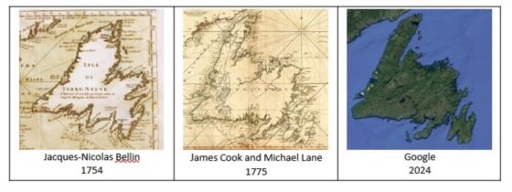
His frequent determination of latitude is mentioned from time to time but his longitude determinations seem to be 'under-reported' at best. His coastal charting work is extraordinarily accurate. See the map comparisons in the attached image. I find it hard to believe that such an accurate map of the Island of Newfoundland could be achieved with just latitude determinations along with the use of plane table coastal survey methods.
There is only one report of an astromonical event that could have produced a reasonbly accurate (for the time) estimate of longitude: a report of his observing an eclipse of the sun (a lunar special case?) on August 5, 1766 at (the appropriately named) Eclipse Island near the community of Burgeo on Island's south coast (47.606510, -57.613669).
I know there's more than a few James Cook aficionados amongst the fine folks who follow Navlist. I hoping thay may be willing to share anything they know about locations where Cook took lunar measurements in the Island's coastal areas and, when back home in England preparing his charts during the off-season, used them to estimate longitude, or had a friend do it for him, which he did with with his Eclipse Island meaurements.
I suppose it's theoretically possible to construct an accurate chart with just latitude estimates, plane table angles, and a SINGLE longitude estimate but, as someone who sails the Island's notoriously disorienting, fog-bound, wave-battered, wind-torn coastal areas, I find it difficult to accept that it's even a remote practical possibility.
Thanks to all who may be interested in helping and apologies for my long-windedness.
Cheers,
Jim.


