Welcome to the NavList Message Boards.

NavList:

A Community Devoted to the Preservation and Practice of Celestial Navigation and Other Methods of Traditional Wayfinding

Compose Your Message

Message:αβγ
Message:abc
Add Images & Files
    Name or NavList Code:
    Email:
       
    Reply
    Re: James Cook's Northeastern North American Coastal Charting
    From: Jim Wyse
    Date: 2024 Mar 1, 23:59 -0800

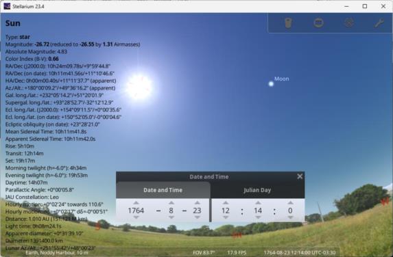
    Those who may still be following this thread will recall my mini-quest to identify specific dates on which Cook took LAN Sun shots to determination latitude and then use Stellarium (me, not Cook) to see whether there would be an obvious 'lunar measurement opportunity' at about the same time.  I'm now adding a second latitude determination occasion (to the first at Cape Norman).  This time, it's Noddy Harbour on 23AUG1764.  Pointing Stellarium at this place and time shows the scene in the attached screen capture.  Note the "in distance" Moon.

    I came across the Noddy Harbour latitude determination date in a 2009 article by Andrew David in the Northern Mariner (on page 399) where he tells us: “By 23 August Cook had recovered sufficiently to land “a little above Noddy Island” and observe for latitude, recording it in his log as 51°34’59”.

    Cook was recovering from a serious 06AUG hand injury and had been brought to Noddy Harbour to be treated by a surgeon aboard a French ship. Those familiar with the circumstances of Cook’s death will know that the scars from this hand injury were used to identify Cook remains.

    Interestingly, Cook had already surveyed the Noddy Harbour area the previous year (1763).  I’m thinking he found the in-distance Moon too much to resist, hand injury notwithstanding.

    Should you wish to locate/see Noddy Harbour. You may do so here. Type ‘noddy’ in the search box (upper left) and then click the blue dot for Noddy Harbour 1764 (or 1763) and much will be revealed.

    Cheers,

    Jim.

    PS Please keep in mind that I’m trying to reconcile why the 1775 Cook-Lane map of the Island of Newfoundland was set in both latitude (no big surprise) and longitude (really big surprise) using field measurements from the 1760s (a period in which many folks hold the view that Cook did know how to measure for longitude.)

    File:


    Reply
    Browse Files

    Drop Files

    NavList

    What is NavList?

    Get a NavList ID Code

    Name:
    (please, no nicknames or handles)
    Email:
    Do you want to receive all group messages by email?
    Yes No

    A NavList ID Code guarantees your identity in NavList posts and allows faster posting of messages.

    Retrieve a NavList ID Code

    Enter the email address associated with your NavList messages. Your NavList code will be emailed to you immediately.
    Email:

    Email Settings

    NavList ID Code:

    Custom Index

    Subject:
    Author:
    Start date: (yyyymm dd)
    End date: (yyyymm dd)

    Visit this site
    Visit this site
    Visit this site
    Visit this site
    Visit this site
    Visit this site