NavList:
A Community Devoted to the Preservation and Practice of Celestial Navigation and Other Methods of Traditional Wayfinding
From: Jim Wyse
Date: 2024 Mar 3, 06:53 -0800
Frank, you wrote: “A few thoughts . . . .”
Many, many thanks for your comments on my use of “in distance” and also pointing out Stellarium’s reporting of “Elongation”. I use your tables for reducing my lunar observations, the quality of which are . . . well . . . sad (my observations that is, not your tables they’re great). With more practice I’m hoping that my observational techniques will see improvement.
Frank, I hope I have been clear that my pointing out Cook’s Cape Norman and Noddy Harbour latitude observations is essentially about the possibility (not the probability) of Cook’s taking lunar measurements, and not necessarily at noon but at some point during an inferred period of good visibility. I hope I have also been clear that any measurements that Cook may have taken would ‘not’ have been reduced to longitude at the time but would have been retained for reduction much later, years later.
I ‘get’ your point that one reasonably good longitude, theoretically, could result in the good registration realized by the 1775 map but as a practical matter I’m finding it difficult to swallow. (Well, suck it up Jimmy, it IS possible!)
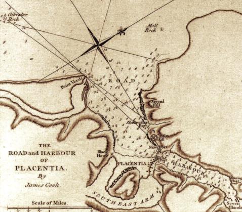
Things could be ‘off’ in many localized circumstances and still be ‘good’ and certainly usable but the ‘offs’ could easily accumulate to significantly distort the overall map. For example, compare Cook’s 1762 chart of Placentia Harbour (image attached) with its present day chart.
i-Boating : Free Marine Navigation Charts & Fishing Maps (gpsnauticalcharts.com)
‘Not bad’ you say but still ‘off’ in many ways. It seems highly improbable (but not impossible) that so much would have to ‘cancel out’ or ‘add up’ to give the overall 1775 result without (more than) a few longitudes here and there. It appears that Cook’s surveys were not connected in a continuous fashion all around the Island and stitching them together would have required some eyeballing and fiddling in the absence of reasonable longitude estimates.
Frank, you mention the role of ‘luck’ in all this and if indeed there’s only one longitude estimate then much luck would have played an important role. Perhaps in a traditional celnav context we should extend the timeless ‘lucky-in’ adage to read: “lucky in life, lucky in love, lucky in longitude”.
Cheers,
Jim


