NavList:
A Community Devoted to the Preservation and Practice of Celestial Navigation and Other Methods of Traditional Wayfinding
From: Frank Reed
Date: 2020 Nov 30, 11:36 -0800
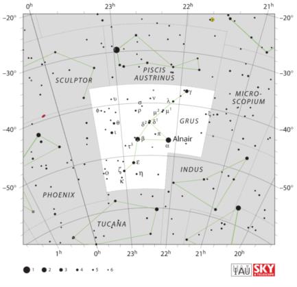
Yesterday at 5:15 EST, just before online "Office Hours", I observed the meridian altitude of one of the official navigation stars which I had never bothered to track down before. It's "Al Na'ir" as listed for decades in navigation tables. The IAU a few years ago accepted all the standard navigation star names as official names including such odious coinages as "Gacrux" but they simplified the spelling of Al Na'ir to Alnair. Since this is now the IAU-sanctioned name, I suspect the "official" nautical almanac(s) will adopt the adjusted spelling soon (could anyone check an official Nautical Almanac for 2020/2021?), and I am using that spelling in all my apps from now on. I also "fixed" the attached star chart.
The declination of Alnair is around 47° S. Given my latitude near 41.5° N, I can see down to a declination of 90-41.5 or 48.5 S. Refraction adds an extra half a degree so Alnair is visible. It works fine for latitude by meridian sight, with the appropriate corrections and since it's only visible when near the meridian, I was planning on looking for it then anway. I found it easily with binoculars. It was right at the limit of naked eye visibility thanks to the high extinction so low in the sky. I found it with my sextant, and there was no problem measuring its altitude: 2° 03'.
My height of eye was around 25 feet by the beach where I was taking my sight. Correction for dip: -5'. At such low altitudes, I worried about unusual temperature and pressure corrections. Air temperature was very close to standard, 50°F or 10°C. I checked after the fact, and air pressure was 30.05 inches Hg (1020 mb). Standard pressure is 29.80 (1010 mb) so that's 1% above normal. Thus, even at this very low angular altitude, the correction for T/P would be an increase in the refraction of only about 1%. Negligible under these conditions. Correction for refraction: -18'. Corrected altitude: 1° 40', and the zenith distance, ZD, is then 88° 20'. Alnair's more exact dec is 46° 52' S or -(46° 52'). Then Lat = ZD + Dec just like the Sun at noon, so (88° 20' - 47°) + 8' or 41° 28'. Actual latitude was 41° 29'. Close enough.
My exact location to the nearest meter: https://goo.gl/maps/nbuq9CF49amFY3xG6. Note that very narrow window looking due South.
Frank Reed
*image credit: IAU and Sky & Telescope magazine (Roger Sinnott & Rick Fienberg) CC BY 3.0, via Wikimedia Commons. (Ahoy, Roger!)


