NavList:
A Community Devoted to the Preservation and Practice of Celestial Navigation and Other Methods of Traditional Wayfinding
From: Frank Reed
Date: 2023 Feb 4, 09:00 -0800
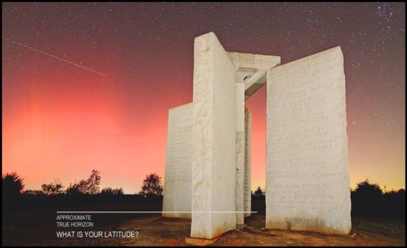
Here's a photo of an odd monument in the south-eastern part of the USA. It used to be little more than one of those roadside novelties that could make a cross-country road trip amusing. But it became the object of demented conspiracy theories, and now it's gone. Can you determine the latitude from the photo? There are at least three ways to do this:
- Look it up and get the latitude from Wikipedia. Easy, but not much fun.
- Figure out the stars and constellations visible in the photo, and then measure some pixels to determine the latitude.
I have added an approximate "true horizon" line to make this work. - Combine the options above: look up the weird monument to get the latitude, and then figure it out from the astronomical clues in the photo.
The third option is probably the best choice. To help you out a little, I will throw in another clue: the infamous WTF comet is today directly behind the top of the right-hand stone in the image (if the stones were still standing today).
Exta credit: there are four navigational stars clearly visible in the photo and at least two more are lost in the light pollution on the lower left. Which navigation stars are visible? :-)
Frank Reed


