Welcome to the NavList Message Boards.

NavList:

A Community Devoted to the Preservation and Practice of Celestial Navigation and Other Methods of Traditional Wayfinding

Compose Your Message

Message:αβγ
Message:abc
Add Images & Files
    Name or NavList Code:
    Email:
       
    Reply
    Re: Latitude and longitude around noon
    From: Peter Hakel
    Date: 2017 Mar 29, 20:35 -0700

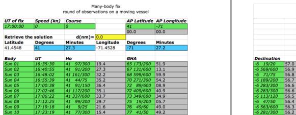
    Revisiting Frank’s LAN data set with the Nautical Almanac method based on least-squares:

    https://www.navigation-spreadsheets.com/lops.html#many_body_fix

    I obtain:

    N 41° 27.3’
    W 71° 27.2’

    which is very close to my earlier two results. This is the most laborious method, using more data and fewer assumptions and approximations, so the result should be quite good. I recall Frank coining the term “rapid-fire fix” some time ago and pointing out that a noon curve is a special case of that.


    Peter Hakel


    File:


    Reply
    Browse Files

    Drop Files

    NavList

    What is NavList?

    Get a NavList ID Code

    Name:
    (please, no nicknames or handles)
    Email:
    Do you want to receive all group messages by email?
    Yes No

    A NavList ID Code guarantees your identity in NavList posts and allows faster posting of messages.

    Retrieve a NavList ID Code

    Enter the email address associated with your NavList messages. Your NavList code will be emailed to you immediately.
    Email:

    Email Settings

    NavList ID Code:

    Custom Index

    Subject:
    Author:
    Start date: (yyyymm dd)
    End date: (yyyymm dd)

    Visit this site
    Visit this site
    Visit this site
    Visit this site
    Visit this site
    Visit this site