NavList:
A Community Devoted to the Preservation and Practice of Celestial Navigation and Other Methods of Traditional Wayfinding
Re: Latitude and longitude around noon
From: Peter Hakel
Date: 2017 Mar 30, 16:10 +0000
From: Peter Hakel
Date: 2017 Mar 30, 16:10 +0000
Brad,
My original post in this thread:
https://navlist.net/Latitude-longitude-around-noon-PeterHakel-mar-2017-g38488
My original post in this thread:
https://navlist.net/Latitude-longitude-around-noon-PeterHakel-mar-2017-g38488
included a Google map screenshot showing a computed location about 1 (statute) mile from the mainland coast, which I thought was a decent result given what's realistically achievable with CelNav. Since I do not calculate any uncertainties or “error bars”, reporting the result “as is” without any additional adjustments before comparing with GPS is really the only way to gauge the accuracy of a chosen method. I assumed that was Frank's goal, since he asked: "Can you determine my latitude and longitude from these sights? How many different ways can you come up with to get a fix from these observations?"
Peter Hakel
-----------------------------------------------------------------------------------------
On Thursday, March 30, 2017, 3:10:22 AM MDT, Brad Morris <NoReply_Morris@navlist.net> wrote:
Hello Peter (and others who have provided an answer)
The careful navigator uses all of the data provided. You will note that Frank attached to his quiz a photo of a large ship and that photo includes a natural sea horizon.
Since the photo was taken at (or near) LAN, we must therefore assume that Frank, when looking due south along his meridian, can see the natural sea horizon.
How many of those of you who provided an answer bothered to check, using one of any number of tools available,that your positional solution afforded Frank that view. For example, Peter, the view from your position is of a smallish lake, which would have no sea horizon. Indeed, my first, and erroneous, answer placed Frank deep onto the woods of Rhode Island, with a great view of a tree. That certainly can't be correct.
Since the latitude from Frank's LAN onservation is fairly certain, I merely scanned along the Rhode Island coast until I could find a PUBLIC beach with that latitude and that view. There were other locations that might have served, but Beavertail Point, in Beavertail State Park seems to fit best.
As a hint to the others, have you checked your answer on Google Earth? Does your positional solution afford a natural sea horizon view due south? If not, you need to rethink your answer.
Brad
On Mar 30, 2017 12:54 AM, "Peter Hakel" <NoReply_PeterHakel@navlist.net> wrote:
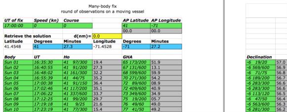
Revisiting Frank’s LAN data set with the Nautical Almanac method based on least-squares:
http://www.navigation- spreadsheets.com/lops.html# many_body_fix
I obtain:
N 41° 27.3’
W 71° 27.2’
which is very close to my earlier two results. This is the most laborious method, using more data and fewer assumptions and approximations, so the result should be quite good. I recall Frank coining the term “rapid-fire fix” some time ago and pointing out that a noon curve is a special case of that.
Peter Hakel
Attached File:


